IMAGES TAKEN NEAR TO
Nower Road, DORKING, RH4 3BS
Introduction
This page details the photographs taken nearby to Nower Road, RH4 3BS by members of the Geograph project.
The Geograph project started in 2005 with the aim of publishing, organising and preserving representative images for every square kilometre of Great Britain, Ireland and the Isle of Man.

There are currently over 7.5m images from over14,400 individuals and you can help contribute to the project by visiting https://www.geograph.org.uk
Image Map
Images are licensed for reuse under creativecommons.org/licenses/by-sa/2.0
Notes
- Clicking on the map will re-center to the selected point.
- The higher the marker number, the further away the image location is from the centre of the postcode.
Image Listing (129 Images Found)
Images are licensed for reuse under creativecommons.org/licenses/by-sa/2.0
Image
Details
Distance
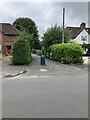
1
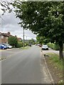
Nower Road
Looking north along Nower Road in Dorking.
Image: © P Harris
Taken: 16 Jul 2024
0.03 miles
2
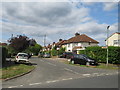
West Bank
Housing north of The Nower. West Bank is an out and back road with two entrances off Hempstead Lane. This section (the eastern arm) dates from the 1930s.
Image: © Ian Capper
Taken: 11 Sep 2016
0.03 miles
3
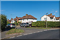
Nower Road
1930s housing off Hampstead Lane (the road in the foreground), north of The Nower.
Image: © Ian Capper
Taken: 11 Sep 2016
0.04 miles
4
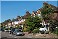
Nower Road, Dorking
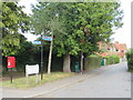
Nower Road is a residential road in the Surrey town of Dorking.
The brown signs attached to the lamp post to the right of the image indicate that this is on the route of The Greensand Way, a long-distance footpath.
Image: © Malc McDonald
Taken: 28 Jul 2019
0.04 miles
5
Nower Road
Start of a footpath linking Nower Road to West Bank in Dorking.
Image: © P Harris
Taken: 16 Jul 2024
0.05 miles
6
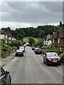
West Bank
Looking south down West Bank, with open space and woodland of The Nower rising beyond.
Image: © P Harris
Taken: 16 Jul 2024
0.05 miles
7
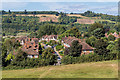
West Bank
Housing in West Bank seen from The Nower. In the background are the North Downs at Denbies.
Image: © Ian Capper
Taken: 11 Sep 2016
0.05 miles
8
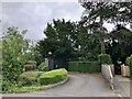
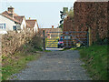
Hampstead Lane
Driveway leading to Nower Lodge, off Hampstead lane, Dorking. The property was formerly Nower Lodge School, founded in 1871, which continued operating until 2022 as an independent preparatory school. It has now been converted to residential use.
Image: © P Harris
Taken: 16 Jul 2024
0.05 miles
9
Nower Road, Dorking
The signpost indicates that this section of road is on the route of The Greensand Way, a long-distance footpath.
Image: © Malc McDonald
Taken: 28 Jul 2019
0.06 miles
10
Footpath 106 meets Hampstead Lane, Dorking
Image: © Robin Webster
Taken: 8 Mar 2011
0.06 miles