IMAGES TAKEN NEAR TO
Downsview Gardens, DORKING, RH4 2DX
Introduction
This page details the photographs taken nearby to Downsview Gardens, RH4 2DX by members of the Geograph project.
The Geograph project started in 2005 with the aim of publishing, organising and preserving representative images for every square kilometre of Great Britain, Ireland and the Isle of Man.

There are currently over 7.5m images from over14,400 individuals and you can help contribute to the project by visiting https://www.geograph.org.uk
Image Map
Images are licensed for reuse under creativecommons.org/licenses/by-sa/2.0
Notes
- Clicking on the map will re-center to the selected point.
- The higher the marker number, the further away the image location is from the centre of the postcode.
Image Listing (125 Images Found)
Images are licensed for reuse under creativecommons.org/licenses/by-sa/2.0
Image
Details
Distance
1
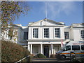
Dorking Hospital
Website: http://www.surreyandsussex.nhs.uk/our-services/hospitals-and-clinics/dorking-hospital/
Image: © Paul Gillett
Taken: 19 Nov 2011
0.04 miles
2
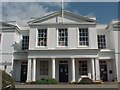
Dorking General Hospital
Originally the Dorking Union Workhouse, it became a hospital in the Second World War, much extended under the NHS after 1948, it is now known as Dorking General Hospital, and is undergoing major refurbishment although a quarter of it is derelict and due for demolition.
Image: © James 'Dan' Hall
Taken: Unknown
0.04 miles
3
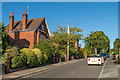
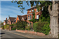
St Pauls Road West
Late Victorian villas in this road off South Street.
Image: © Ian Capper
Taken: 11 Sep 2016
0.07 miles
4
St Pauls Road West
Late Victorian villas in this road off South Street.
Image: © Ian Capper
Taken: 24 Sep 2016
0.08 miles
5
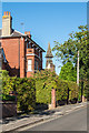
St Pauls Road West
Late Victorian villa in this road off South Street. In the background is the steeple of St Paul's Church.
Image: © Ian Capper
Taken: 11 Sep 2016
0.08 miles
6
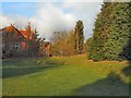
Gardens near Dorking General Hospital
Close to Horsham Road
Image: © Paul Gillett
Taken: 19 Nov 2011
0.08 miles
7
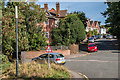
Cliftonville
1880s road off Horsham Road, named after Joseph Clift, High Street Chemist and member of the Dorking District Local Board (the local council at the time), who was behind its development.
Image: © Ian Capper
Taken: 24 Sep 2016
0.10 miles
9
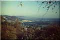
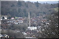
Dorking From the West
View, from above Abinger Hammer, along the foot of the North Downs to Westcott and Dorking.
Image: © Colin Smith
Taken: 1 Oct 1985
0.11 miles