IMAGES TAKEN NEAR TO
Beresford Road, DORKING, RH4 2DF
Introduction
This page details the photographs taken nearby to Beresford Road, RH4 2DF by members of the Geograph project.
The Geograph project started in 2005 with the aim of publishing, organising and preserving representative images for every square kilometre of Great Britain, Ireland and the Isle of Man.

There are currently over 7.5m images from over14,400 individuals and you can help contribute to the project by visiting https://www.geograph.org.uk
Image Map
Images are licensed for reuse under creativecommons.org/licenses/by-sa/2.0
Notes
- Clicking on the map will re-center to the selected point.
- The higher the marker number, the further away the image location is from the centre of the postcode.
Image Listing (256 Images Found)
Images are licensed for reuse under creativecommons.org/licenses/by-sa/2.0
Image
Details
Distance
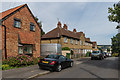
1
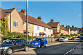
Beresford Road
Estate built for the then Dorking Urban District Council in 1927-8.
Image: © Ian Capper
Taken: 11 Sep 2016
0.03 miles
2
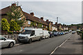
Beresford Road
Estate built for the then Dorking Urban District Council in 1927-8.
Image: © Ian Capper
Taken: 24 Sep 2016
0.04 miles
3
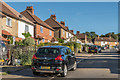
Beresford Road
Estate built for the then Dorking Urban District Council in 1927-8.
Image: © Ian Capper
Taken: 11 Sep 2016
0.05 miles
4
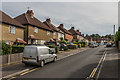
Beresford Road
Estate built for the then Dorking Urban District Council in 1927-8.
Image: © Ian Capper
Taken: 24 Sep 2016
0.07 miles
5
Marlborough Road
Estate built for the then Dorking Urban District Council in 1925-6 (although the nearest house is clearly more recent).
Image: © Ian Capper
Taken: 24 Sep 2016
0.08 miles
6
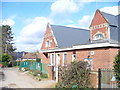
St Paul's School
CE Primary school on St Paul's Road in south Dorking. Modern extensions are to right, off camera.
Image: © Colin Smith
Taken: 7 Mar 2009
0.08 miles
7
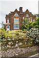
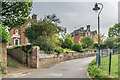
3 - 4 Rose Hill
Mid 19th Century semi-detached villas in Rose Hill. Grade II listed - see https://www.historicengland.org.uk/listing/the-list/list-entry/1229457. The flint wall in front, which features galleting in both the main section and the sandstone rubble base, are separately grade II listed - see https://www.historicengland.org.uk/listing/the-list/list-entry/1229458.
Image: © Ian Capper
Taken: 24 Sep 2016
0.08 miles
8
3 - 4 Rose Hill
Mid 19th Century semi-detached villas in Rose Hill. Grade II listed - see https://www.historicengland.org.uk/listing/the-list/list-entry/1229457. The flint walls in front, which feature galleting in both the main section and the sandstone rubble base, are separately grade II listed - see https://www.historicengland.org.uk/listing/the-list/list-entry/1229458.
Image: © Ian Capper
Taken: 24 Sep 2016
0.08 miles
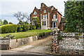
9
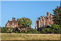
3 - 4 and 5 - 6 Rose Hill
A pair of substantial semi detached mid 19th Century villas on Rose Hill. Both buildings are grade II listed - see https://www.historicengland.org.uk/listing/the-list/list-entry/1229457 and https://www.historicengland.org.uk/listing/the-list/list-entry/1229459 respectively.
Image: © Ian Capper
Taken: 11 Sep 2016
0.09 miles
10
3 - 6 Rose Hill
Two pairs of large semi-detached houses built by the Dorking Villa Building Company between 1846 and 1848. Both buildings are grade II listed - see https://historicengland.org.uk/listing/the-list/list-entry/1229457?section=official-list-entry and https://historicengland.org.uk/listing/the-list/list-entry/1229459?section=official-list-entry respectively.
Image: © Ian Capper
Taken: 11 Oct 2023
0.09 miles