IMAGES TAKEN NEAR TO
Goodwyns Place, DORKING, RH4 2AW
Introduction
This page details the photographs taken nearby to Goodwyns Place, RH4 2AW by members of the Geograph project.
The Geograph project started in 2005 with the aim of publishing, organising and preserving representative images for every square kilometre of Great Britain, Ireland and the Isle of Man.

There are currently over 7.5m images from over14,400 individuals and you can help contribute to the project by visiting https://www.geograph.org.uk
Image Map
Images are licensed for reuse under creativecommons.org/licenses/by-sa/2.0
Notes
- Clicking on the map will re-center to the selected point.
- The higher the marker number, the further away the image location is from the centre of the postcode.
Image Listing (52 Images Found)
Images are licensed for reuse under creativecommons.org/licenses/by-sa/2.0
Image
Details
Distance
1
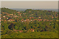
Tower Hill, Dorking
Viewed from Denbies Hillside. In the foreground is Milton Court (see Image).
Image: © Ian Capper
Taken: 22 May 2010
0.04 miles
2
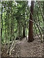
Devil's Den woods, Dorking
Footpath contouring around steep slope through Devil's Den woods, Dorking.
Image: © P Harris
Taken: 28 Jun 2024
0.06 miles
3
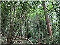
Devils Den woods, Dorking
Semi ancient woodland within Devils Den woods, Dorking.
Image: © P Harris
Taken: 28 Jun 2024
0.06 miles
4
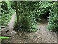
Devil's Den woods, Dorking
Fork in the path shortly after leaving Martineau Drive and entering Devil's Den woods.
Image: © P Harris
Taken: 28 Jun 2024
0.08 miles
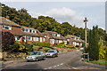
5
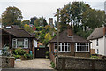
Bungalows, South Terrace
A pair of bungalows on South Terrace. In the background is the Tower on Tower Hill (see Image).
Image: © Ian Capper
Taken: 21 Oct 2016
0.09 miles
6
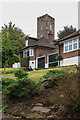
The Tower, Tower Hill
Folly tower on Tower Hill, built in 1829 by Arthur Dendy, a member of a prominent Surrey/Sussex landowning family. Seen here above a pair of bungalows lower down Tower Hill. Grade II listed - see https://www.historicengland.org.uk/listing/the-list/list-entry/1229825.
Image: © Ian Capper
Taken: 21 Oct 2016
0.09 miles
7

The Tower, Tower Hill
Folly tower on Tower Hill, built in 1829 by Arthur Dendy, a member of a prominent Surrey/Sussex landowning family. Grade II listed - see https://www.historicengland.org.uk/listing/the-list/list-entry/1229825.
Image: © Ian Capper
Taken: 21 Oct 2016
0.09 miles
8
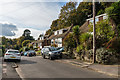
Claygate Road
Late 1950s/early 1960s housing built on the southern slopes of Tower Hill, on land previously belonging to Goodwyns Place.
Image: © Ian Capper
Taken: 21 Oct 2016
0.10 miles
9
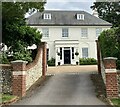
Tower Hill, Dorking
Cleveland House, Tower Hill, Dorking.
Image: © P Harris
Taken: 28 Jun 2024
0.10 miles
10
Claygate Road
Late 1950s/early 1960s housing built on the southern slopes of Tower Hill, on land previously belonging to Goodwyns Place.
Image: © Ian Capper
Taken: 21 Oct 2016
0.11 miles