IMAGES TAKEN NEAR TO
South Terrace, DORKING, RH4 2AD
Introduction
This page details the photographs taken nearby to South Terrace, RH4 2AD by members of the Geograph project.
The Geograph project started in 2005 with the aim of publishing, organising and preserving representative images for every square kilometre of Great Britain, Ireland and the Isle of Man.

There are currently over 7.5m images from over14,400 individuals and you can help contribute to the project by visiting https://www.geograph.org.uk
Image Map
Images are licensed for reuse under creativecommons.org/licenses/by-sa/2.0
Notes
- Clicking on the map will re-center to the selected point.
- The higher the marker number, the further away the image location is from the centre of the postcode.
Image Listing (53 Images Found)
Images are licensed for reuse under creativecommons.org/licenses/by-sa/2.0
Image
Details
Distance
1
Orchard Way
Late Victorian terraced cottages on Orchard Way. Originally this was part of Orchard Road, part of which still exists to the west of here. However in the 1980s or so, Orchard Road was split into two, with the upper part, seen here, renamed and given its own access from Harrow Road East.
Image: © Ian Capper
Taken: 21 Oct 2016
0.08 miles
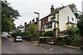
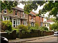
3
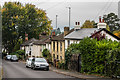
Harrow Road East
Late Victorian cottages in Harrow Road East.
Image: © Ian Capper
Taken: 21 Oct 2016
0.10 miles
4
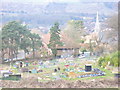
Allotments by Tower Hill
Rural-urban fringe activity on the slopes of Tower Hill on the southern edge of Dorking. St Martin's spire is in the middle distance (right). In the far distance are the lower slopes of Ranmore Common.
Image: © Colin Smith
Taken: 7 Mar 2009
0.11 miles
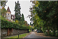
5
Priory Lodge
House on Harrow Road East, the wing of a larger building which the 1896 and 1914 1:2500 maps mark as the water works of the Dorking Water Company.
Image: © Ian Capper
Taken: 21 Oct 2016
0.11 miles
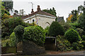
6
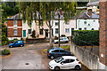
South Terrace, Dorking
There seems to be something a bit bohemian about this hilly corner of Dorking, and I was reminded of Hampstead as it was back in my student days. The 'chateau' is No 51, and has been divided into flats.
There are dozens of big horse-chestnut trees here, and - on this afternoon in early October - conkers were hitting the ground at a rate of three or four per minute. The conker trees appeared to be in good health, but - given the blighted state of chestnut trees in the London suburbs - I fear for their longer term future.
Image: © Stefan Czapski
Taken: 7 Oct 2013
0.11 miles
7
Harrow Road East
Late Victorian/Edwardian houses in Harrow Road East. Older maps show this section of road as part of Tower Hill, a name now used for addresses on the higher ground behind these houses.
Image: © Ian Capper
Taken: 21 Oct 2016
0.12 miles
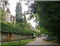
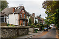
8
South Terrace
Looking along South Terrace from near its junction with Harrow Road East. On the left is Normanholt, a large mid Victorian house dating from the start of the development of this area, now subdivided into flats.
Image: © Ian Capper
Taken: 21 Oct 2016
0.12 miles
9
Cottages in Harrow Road East, Dorking
Image: © Stefan Czapski
Taken: 7 Oct 2013
0.12 miles
10
Harrow Road East
Late Victorian/Edwardian houses in Harrow Road East. Older maps show this section of road as part of Tower Hill, a name now used for addresses on the higher ground behind these houses.
Image: © Ian Capper
Taken: 21 Oct 2016
0.13 miles