IMAGES TAKEN NEAR TO
Deepdene Avenue, DORKING, RH4 1SS
Introduction
This page details the photographs taken nearby to Deepdene Avenue, RH4 1SS by members of the Geograph project.
The Geograph project started in 2005 with the aim of publishing, organising and preserving representative images for every square kilometre of Great Britain, Ireland and the Isle of Man.

There are currently over 7.5m images from over14,400 individuals and you can help contribute to the project by visiting https://www.geograph.org.uk
Image Map
Images are licensed for reuse under creativecommons.org/licenses/by-sa/2.0
Notes
- Clicking on the map will re-center to the selected point.
- The higher the marker number, the further away the image location is from the centre of the postcode.
Image Listing (284 Images Found)
Images are licensed for reuse under creativecommons.org/licenses/by-sa/2.0
Image
Details
Distance
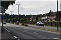
1
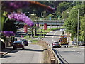
London Road, Dorking
Looking north along the thundering A24 towards the railway bridge carrying the North Downs Line between Guildford and Redhill.
www.visitdorking.com
Image: © Colin Smith
Taken: 9 Aug 2012
0.03 miles
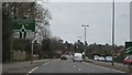
4

Dorking Sign
On the A24, south of Dorking Station
Image: © Paul Gillett
Taken: 19 Nov 2011
0.03 miles
6
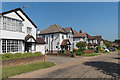
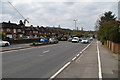
Deepdene Vale
Houses built in the second half of the 1920s by local businessman and councillor, Maurice Chance, on what was previous part of the estate of The Deepdene, which was being sold off at the time.
Image: © Ian Capper
Taken: 20 May 2018
0.06 miles
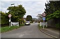
9
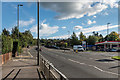
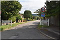
Deepdene Avenue
The A24 at its junction with London Road (off to the right of the photo). This section was built in the 1930s as part of the Dorking bypass, the conversion to a dual carriageway coming later, in the 1960s. Prior to the building of the bypass, all traffic went along London Road, and then High Street and South Street, with the course of the current road being the start of the driveway to The Deepdene (see http://www.francisfrith.com/uk/dorking/dorking-deepdene-avenue-1906_54672 for a photo).
Image: © Ian Capper
Taken: 10 Oct 2016
0.08 miles