IMAGES TAKEN NEAR TO
London Road, DORKING, RH4 1JA
Introduction
This page details the photographs taken nearby to London Road, RH4 1JA by members of the Geograph project.
The Geograph project started in 2005 with the aim of publishing, organising and preserving representative images for every square kilometre of Great Britain, Ireland and the Isle of Man.

There are currently over 7.5m images from over14,400 individuals and you can help contribute to the project by visiting https://www.geograph.org.uk
Image Map
Images are licensed for reuse under creativecommons.org/licenses/by-sa/2.0
Notes
- Clicking on the map will re-center to the selected point.
- The higher the marker number, the further away the image location is from the centre of the postcode.
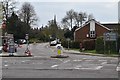
Image Listing (287 Images Found)
Images are licensed for reuse under creativecommons.org/licenses/by-sa/2.0
Image
Details
Distance
2
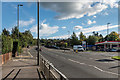
London Road
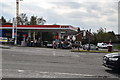
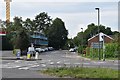
London Road at its junction with the A24 Deepdene Avenue (in the background). Deepdene Avenue was built in the 1930s as part of the Dorking bypass. Prior to the building of the bypass, all traffic went along London Road, and then High Street and South Street, with the course of the current A24 being the start of the driveway to The Deepdene (see http://www.francisfrith.com/uk/dorking/dorking-deepdene-avenue-1906_54672 for a photo).
Image: © Ian Capper
Taken: 10 Oct 2016
0.02 miles
6
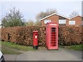
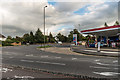
Post Box and K6 Phone Kiosk
RH4 111 Fairfield Drive (Dorking)
Image: © The Saunterer
Taken: 6 Mar 2013
0.02 miles
9
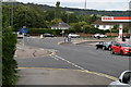
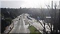
Deepdene Avenue
The A24 at its junction with London Road (off to the right of the photo). This section was built in the 1930s as part of the Dorking bypass, the conversion to a dual carriageway coming later, in the 1960s. Prior to the building of the bypass, all traffic went along London Road, and then High Street and South Street, with the course of the current road being the start of the driveway to The Deepdene (see http://www.francisfrith.com/uk/dorking/dorking-deepdene-avenue-1906_54672 for a photo).
Image: © Ian Capper
Taken: 10 Oct 2016
0.03 miles
