IMAGES TAKEN NEAR TO
London Road, DORKING, RH4 1GS
Introduction
This page details the photographs taken nearby to London Road, RH4 1GS by members of the Geograph project.
The Geograph project started in 2005 with the aim of publishing, organising and preserving representative images for every square kilometre of Great Britain, Ireland and the Isle of Man.

There are currently over 7.5m images from over14,400 individuals and you can help contribute to the project by visiting https://www.geograph.org.uk
Image Map
Images are licensed for reuse under creativecommons.org/licenses/by-sa/2.0
Notes
- Clicking on the map will re-center to the selected point.
- The higher the marker number, the further away the image location is from the centre of the postcode.
Image Listing (282 Images Found)
Images are licensed for reuse under creativecommons.org/licenses/by-sa/2.0
Image
Details
Distance
1
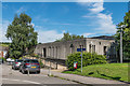
Former Magistrates' Court
Former Magistrates' Court in what were originally the grounds of Pippbrook House. Built around 1970, it closed in July 2012, and plans for demolition and replacement by retirement flats were approved in early 2017.
Image: © Ian Capper
Taken: 11 Aug 2017
0.01 miles
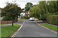
2
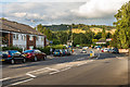
London Road
Looking along London Road towards its junction with the A24 Deepdene Avenue (which north from the junction takes over the name London Road). This is the original main road through Dorking, before Deepdene Avenue was built in the 1930s as the town bypass.
In the background is Box Hill.
Image: © Ian Capper
Taken: 10 Oct 2016
0.02 miles
3
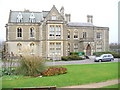
Pippbrook House
Former mansion, now this fine stone building is the Dorking Public Library.
Image: © Colin Smith
Taken: 16 Nov 2008
0.02 miles
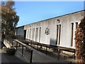
5
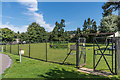
Pippbrook Bowls Club
Bowling green in what were originally the grounds of Pippbrook House. The club was founded in 1937.
Image: © Ian Capper
Taken: 11 Aug 2017
0.03 miles
8
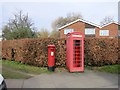
Post Box and K6 Phone Kiosk
RH4 111 Fairfield Drive (Dorking)
Image: © The Saunterer
Taken: 6 Mar 2013
0.04 miles
9
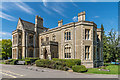
Pippbrook House
Built in 1856 for William Henry Forman, millionaire owner of the Penydarren ironworks at Merthyr Tydfil, to replace an earlier house on the site. It was designed by Sir George Gilbert Scott in Victorian Gothic style.
From 1891 to 1928 it was owned by the Aggs banking family, although towards the end of their ownership it fell into disrepair, before being sold to a John Alexander Lloyd in 1928 with the aim of demolishing the house, so that the site could be redeveloped. However it was subsequently rescued by Dorking Urban District Council who used it for council offices from 1931 until moving to their new premises on Reigate Road in 1984. From 1985 until the end of 2011 it was leased to Surrey County Council for use as Dorking's public library.
Grade II* listed, particularly for its interior features - see www.historicengland.org.uk/listing/the-list/list-entry/1028875.
Image: © Ian Capper
Taken: 11 Aug 2017
0.04 miles
10
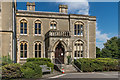
Pippbrook House
The entrance to Pippbrook House, built in 1856 for William Henry Forman, millionaire owner of the Penydarren ironworks at Merthyr Tydfil, to replace an earlier house on the site. It was designed by Sir George Gilbert Scott in Victorian Gothic style.
From 1891 to 1928 it was owned by the Aggs banking family, although towards the end of their ownership it fell into disrepair, before being sold to a John Alexander Lloyd in 1928 with the aim of demolishing the house, so that the site could be redeveloped. However it was subsequently rescued by Dorking Urban District Council who used it for council offices from 1931 until moving to their new premises on Reigate Road in 1984. From 1985 until the end of 2011 it was leased to Surrey County Council for use as Dorking's public library.
Grade II* listed, particularly for its interior features - see www.historicengland.org.uk/listing/the-list/list-entry/1028875.
Image: © Ian Capper
Taken: 11 Aug 2017
0.04 miles