IMAGES TAKEN NEAR TO
Chalkpit Lane, DORKING, RH4 1AJ
Introduction
This page details the photographs taken nearby to Chalkpit Lane, RH4 1AJ by members of the Geograph project.
The Geograph project started in 2005 with the aim of publishing, organising and preserving representative images for every square kilometre of Great Britain, Ireland and the Isle of Man.

There are currently over 7.5m images from over14,400 individuals and you can help contribute to the project by visiting https://www.geograph.org.uk
Image Map
Images are licensed for reuse under creativecommons.org/licenses/by-sa/2.0
Notes
- Clicking on the map will re-center to the selected point.
- The higher the marker number, the further away the image location is from the centre of the postcode.
Image Listing (449 Images Found)
Images are licensed for reuse under creativecommons.org/licenses/by-sa/2.0
Image
Details
Distance
1
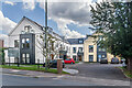
Vine Court
Development of flats completed in 2020, replacing a previous office building.
Image: © Ian Capper
Taken: 3 Aug 2021
0.01 miles
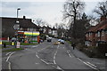
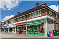
3
Dorking - Dolphin Fish & Chips
Chalkpit Lane - suburban shopping parade in western Dorking.
Image: © Colin Smith
Taken: 28 Sep 2015
0.01 miles
4
2 - 8 Ranmore Road
c1930s shopping parade at the junction of Ranmore Road, Chalkpit Lane and Station Road.
Image: © Ian Capper
Taken: 3 Aug 2021
0.04 miles
5
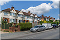
Chalkpit Lane
Housing on Chalkpit Lane built by London builder A F Davis in 1934-35 on land bought from the Denbies Estate by local businessman and councillor, Maurice Chance.
Image: © Ian Capper
Taken: 3 Aug 2021
0.04 miles
6
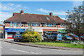
2 - 8 Ranmore Road
c1930s shopping parade at the junction of Ranmore Road, Chalkpit Lane and Station Road.
Image: © Ian Capper
Taken: 13 Sep 2019
0.04 miles
7
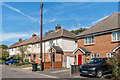
Portland Road
c1930s housing (other than the building on the right, which was one of three buildings, Portland Cottages, built in the early 21st Century on the site of a factory called Trimster House). What is unusual about this road is that the original houses were lettered not numbered, with the letters built into the walls of each house in coloured bricks, as can clearly be seen here on the pair of houses in the centre of this photo.
Image: © Ian Capper
Taken: 13 Sep 2019
0.04 miles
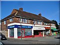
8
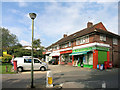
The Triangle Convenience Store
Plus a Chinese and an Indian food shop, and one called The Jam Pot.
Image: © Des Blenkinsopp
Taken: 18 Sep 2014
0.04 miles
9
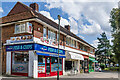
2 - 8 Ranmore Road
c1930s shopping parade at the junction of Ranmore Road, Chalkpit Lane and Station Road.
Image: © Ian Capper
Taken: 3 Aug 2021
0.04 miles