IMAGES TAKEN NEAR TO
Kiln Lane, BETCHWORTH, RH3 7LZ
Introduction
This page details the photographs taken nearby to Kiln Lane, RH3 7LZ by members of the Geograph project.
The Geograph project started in 2005 with the aim of publishing, organising and preserving representative images for every square kilometre of Great Britain, Ireland and the Isle of Man.

There are currently over 7.5m images from over14,400 individuals and you can help contribute to the project by visiting https://www.geograph.org.uk
Image Map
Images are licensed for reuse under creativecommons.org/licenses/by-sa/2.0
Notes
- Clicking on the map will re-center to the selected point.
- The higher the marker number, the further away the image location is from the centre of the postcode.
Image Listing (146 Images Found)
Images are licensed for reuse under creativecommons.org/licenses/by-sa/2.0
Image
Details
Distance
1
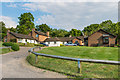
Poland House
Old people's home started in the 1950s. The will of Sidney Michael Poland, who lived in Betchworth Manor, stated that the house and grounds should be used as an old people's home for residents of Brockham. However, on the death of his sister in the 1950s, it was found that Brockham Manor was unsuitable and it was demolished, with a number of houses built on the grounds, but with the largest plot retained to provide a purpose built home, named after its original benefactor.
Image: © Ian Capper
Taken: 13 Jun 2014
0.02 miles
2
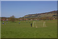
Big Field
Brockham Big Field is owned by the National Trust, who acquired the freehold in 1966. It is leased to Dorking Rugby Club and Mole Valley District Council for sports use. In the background is Box Hill.
Image: © Ian Capper
Taken: 17 Apr 2010
0.06 miles
4
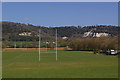
Big Field
Brockham Big Field is owned by the National Trust, who acquired the freehold in 1966. It is leased to Dorking Rugby Club and Mole Valley District Council for sports use. In the background are the former Brockham Quarries.
Image: © Ian Capper
Taken: 17 Apr 2010
0.09 miles
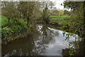
5
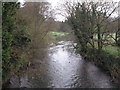
River Mole looking upstream
Viewed from the main road at Borough bridge.
Image: © Paul E Smith
Taken: 20 Mar 2011
0.09 miles
6
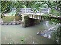
Footbridge over The River Mole
This concrete bridge is standing on the ruins of an earlier brick structfure
Image: © Martyn Davies
Taken: 19 Aug 2007
0.10 miles
7
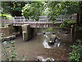
River Mole Footbridge
East of brockham village where a new deck bridge is in place. Note the old cutwater foundation in the river.
Image: © Colin Smith
Taken: 29 Jun 2012
0.10 miles
10
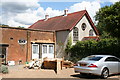
Former chapel, Brockham Green, Surrey
I am unable to say what the particular branch of Christianity was on offer at this establishment, but it is now closed for worship and seems to be in the course of incorporation into the adjacent house.
Image: © Dr Neil Clifton
Taken: 7 Aug 2007
0.12 miles