IMAGES TAKEN NEAR TO
Brockham Green, BETCHWORTH, RH3 7JS
Introduction
This page details the photographs taken nearby to Brockham Green, RH3 7JS by members of the Geograph project.
The Geograph project started in 2005 with the aim of publishing, organising and preserving representative images for every square kilometre of Great Britain, Ireland and the Isle of Man.

There are currently over 7.5m images from over14,400 individuals and you can help contribute to the project by visiting https://www.geograph.org.uk
Image Map
Images are licensed for reuse under creativecommons.org/licenses/by-sa/2.0
Notes
- Clicking on the map will re-center to the selected point.
- The higher the marker number, the further away the image location is from the centre of the postcode.
Image Listing (183 Images Found)
Images are licensed for reuse under creativecommons.org/licenses/by-sa/2.0
Image
Details
Distance
2
The Pound Plaque
Close up of plaque detailing information about "The Pound"
Image: © Stephen Knox
Taken: 23 May 2015
0.02 miles
3
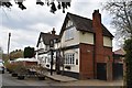
The Royal Oak, Brockham
The Royal Oak pub and adjacent cottages next to Brockham Green.
Image: © Paul E Smith
Taken: 20 Mar 2011
0.02 miles
4
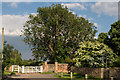
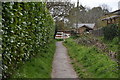
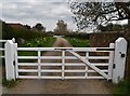
Entrance to Brockham Court Farm
Gate at the entrance to Brockham Court Farm. To the right of the gate is The Pound.
Image: © Ian Capper
Taken: 13 Jun 2014
0.02 miles
5
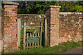
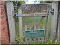
The Pound
An area for impounding cattle or horses found grazing on Brockham Green, prohibited by an 1812 Act of Parliament (see http://www.brockhamhistory.org/brockham-facts/interesting-documents/act-of-parliament-1812/ - under Clause 40, only poultry were allowed there). Fines enabling their release were payable to the Lord of the Manor (of Betchworth Castle).
Grade II listed - see www.historicengland.org.uk/listing/the-list/list-entry/1028917.
For another view see Image and for a wider view see Image
Image: © Ian Capper
Taken: 13 Jun 2014
0.02 miles
6
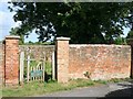
Brockham Pound
The pound lies at the eastern end of a minor road running east from the green, itself known as Brockham Green. The sign on the gate reads: "The Pound. Brockham's own Act of Parliament (1812) allowed only poultry to depasture the Green. Cattle or horses were impounded until a fine had been paid to the Lord of the Manor." The Act would have been the Brockham and East Betchworth (Surrey) Inclosure Act 1812, which parcelled up and inclosed the common fields and common land in the surrounding area, but left intact the common land in the village centre, which had long since become the green.
Image: © Hugh Craddock
Taken: 22 Jun 2008
0.02 miles
8
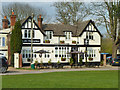
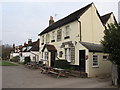
The Grumpy Mole restaurant, Brockham Green
Also inscribed 'Inn on the Green'. Formerly the Dukes Head pub.
Image: © Robin Webster
Taken: 22 Mar 2011
0.03 miles
9
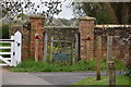
The Pound, Brockham
Grade II listed. https://historicengland.org.uk/listing/the-list/list-entry/1028917
Image: © N Chadwick
Taken: 12 Apr 2019
0.03 miles