IMAGES TAKEN NEAR TO
Wellhouse Lane, BETCHWORTH, RH3 7HH
Introduction
This page details the photographs taken nearby to Wellhouse Lane, RH3 7HH by members of the Geograph project.
The Geograph project started in 2005 with the aim of publishing, organising and preserving representative images for every square kilometre of Great Britain, Ireland and the Isle of Man.

There are currently over 7.5m images from over14,400 individuals and you can help contribute to the project by visiting https://www.geograph.org.uk
Image Map
Images are licensed for reuse under creativecommons.org/licenses/by-sa/2.0
Notes
- Clicking on the map will re-center to the selected point.
- The higher the marker number, the further away the image location is from the centre of the postcode.
Image Listing (9 Images Found)
Images are licensed for reuse under creativecommons.org/licenses/by-sa/2.0
Image
Details
Distance
1
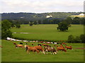
Footpath from Gadbrook House to Gadbrook Farm
Presumably a longstanding route, leading as it does from "the house" to "the farm". In the far distance are the North Downs, with the former Betchworth Quarry visible on the left. The snow on the ground is from a fall a week previously.
Image: © Ian Capper
Taken: 26 Dec 2010
0.17 miles
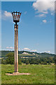
2
Betchworth Jubilee Beacon
Beacon above Wellhouse Road. Photographs of the Betchworth Diamond Jubilee celebrations suggest that this was the one lit for the Jubilee celebrations, although it doesn't appear on official listings and I have been unable to locate any further information online.
In the background is Leith Hill.
Image: © Ian Capper
Taken: 22 Jul 2012
0.18 miles
3
Betchworth Jubilee Beacon
Beacon above Wellhouse Road. Photographs of the Betchworth Diamond Jubilee celebrations suggest that this was the one lit for the Jubilee celebrations, although it doesn't appear on official listings and I have been unable to locate any further information online.
In the background is the former Betchworth Quarry.
Image: © Ian Capper
Taken: 22 Jul 2012
0.18 miles
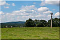
4
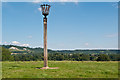
Betchworth Jubilee Beacon
Beacon above Wellhouse Road. Photographs of the Betchworth Diamond Jubilee celebrations suggest that this was the one lit for the Jubilee celebrations, although it doesn't appear on official listings and I have been unable to locate any further information online.
In the background is the line of the North Downs, from the former Betchworth Quarry on the left to Colley Hill above Reigate on the right.
Image: © Ian Capper
Taken: 22 Jul 2012
0.18 miles
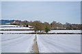
5
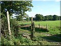
Footpath south of Wellhouse Road
looking south-east
Image: © Andrew Longton
Taken: 20 Sep 2005
0.18 miles
6
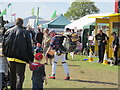
One Man Band at the Cowpie Country Show May 2013
A regular at the annual show held near Betchwoeth, Dorking
Image: © Richard Rogerson
Taken: 12 May 2013
0.18 miles
7
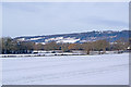
Towards Boxhill
The line of the North Downs, with Box Hill on the far left. The house on the crest of the hill on the right is Brockham Warren, built by Mackley Browne in 1816, and subsequently the home of Sir Benjamin Vincent Sellon Brodie, Bt, the first president of the General Medical Council.
The snow cover is from a fall a week previously.
Image: © Ian Capper
Taken: 26 Dec 2010
0.20 miles
8
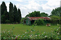
A shed within a shed
A wooded shed under an old corrugated iron canopy. The field is set out for archery, presumably the shed is a sort of pavilion. The club is believed to be the Reigate Priory Bowmen, named after their former location.
Image: © Robin Webster
Taken: 29 Jun 2010
0.24 miles