IMAGES TAKEN NEAR TO
Tranquil Dale, BETCHWORTH, RH3 7EE
Introduction
This page details the photographs taken nearby to Tranquil Dale, RH3 7EE by members of the Geograph project.
The Geograph project started in 2005 with the aim of publishing, organising and preserving representative images for every square kilometre of Great Britain, Ireland and the Isle of Man.

There are currently over 7.5m images from over14,400 individuals and you can help contribute to the project by visiting https://www.geograph.org.uk
Image Map (Loading...)


Getting Data...Please wait
Leaflet Map data © OpenStreetMap
Images are licensed for reuse under creativecommons.org/licenses/by-sa/2.0
Notes
- Clicking on the map will re-center to the selected point.
- The higher the marker number, the further away the image location is from the centre of the postcode.
Image Listing (14 Images Found)
Images are licensed for reuse under creativecommons.org/licenses/by-sa/2.0
Image
Details
Distance
1
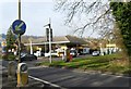
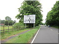
Shell service station, Buckland, Surrey
Image: © nick macneill
Taken: 11 Jan 2013
0.06 miles
2
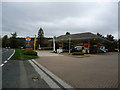
Shell petrol station, Buckland
Formerly Fishers, a Volvo car dealership
Image: © Stacey Harris
Taken: 26 Sep 2010
0.09 miles
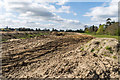
4
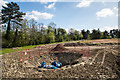
Route of new Water Main
During 2013/2014, Sutton and East Surrey Water have been undertaking a major project to lay a new 32" water main from Outwood to Buckland. Here is its route as it skirts Buckland village before tunnelling under the A25. The reason for this complex set of joints (see Image for close up) is unclear.
Image: © Ian Capper
Taken: 18 Apr 2014
0.11 miles
5
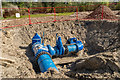
Water Main joint
During 2013/early 2014, Sutton and East Surrey Water have been undertaking a major project to lay a new 32" water main from Outwood to Buckland.
Here is a close up of the joint in Image
Image: © Ian Capper
Taken: 18 Apr 2014
0.11 miles
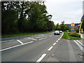
6
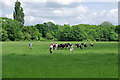
Walkers and cattle
Walkers taking the little-used path from Rectory Lane to the A25 attract a herd of curious cattle. This path, behind the viewpoint, is confined to a fenced narrow alley which is, or was in 2008, a linear nettle bed. A local resident pointed out a far preferable but unofficial alternative, into the end of the residential road called Tranquil Dale.
Image: © Robin Webster
Taken: 5 Jun 2008
0.12 miles
7
Route of new Water Main
During 2013/early 2014, Sutton and East Surrey Water have been undertaking a major project to lay a new 32" water main from Outwood to Buckland. Here is its route as it skirts Buckland village.
Image: © Ian Capper
Taken: 18 Apr 2014
0.13 miles
8
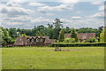
Petty's Barn and Petty's Farm House
Former farm on Rectory Lane. Petty's Farm House, on the right, dates from the 17th Century and is grade II listed - see www.historicengland.org.uk/listing/the-list/list-entry/1028756.
Image: © Ian Capper
Taken: 27 May 2020
0.20 miles
10
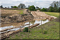
Route of new Water Main
During 2013/early 2014, Sutton and East Surrey Water have been undertaking a major project to lay a new 32" water main from Outwood to Buckland. Here is its route as it skirts Buckland village.
Image: © Ian Capper
Taken: 18 Apr 2014
0.21 miles