IMAGES TAKEN NEAR TO
Reigate Road, BETCHWORTH, RH3 7EA
Introduction
This page details the photographs taken nearby to Reigate Road, RH3 7EA by members of the Geograph project.
The Geograph project started in 2005 with the aim of publishing, organising and preserving representative images for every square kilometre of Great Britain, Ireland and the Isle of Man.

There are currently over 7.5m images from over14,400 individuals and you can help contribute to the project by visiting https://www.geograph.org.uk
Image Map
Images are licensed for reuse under creativecommons.org/licenses/by-sa/2.0
Notes
- Clicking on the map will re-center to the selected point.
- The higher the marker number, the further away the image location is from the centre of the postcode.
Image Listing (240 Images Found)
Images are licensed for reuse under creativecommons.org/licenses/by-sa/2.0
Image
Details
Distance
1
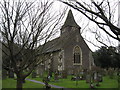
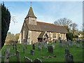
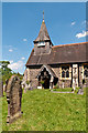
St Mary the Virgin Church, Buckland
The church is thought to date back to 1380 although in 1860, it did undergo a large refurbishment under the direction of architect Henry Woodyer (St Martin’s Dorking was his design). The bell-tower has a shingled spire, and internally is a structure of 14th century oak.
See http://www.stmarythevirginbuckland.net/resources_history.php
Image: © Richard Rogerson
Taken: 22 Jan 2011
0.02 miles
2
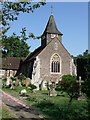
Buckland Church
Though the church has medieval origins, Ian Nairn (writing in the Surrey volume of Pevsner's 'The Buildings of England') points out that what you see from outside dates from the 1860's. The stumpy shingled spire is typical of Surrey, and so is the main building material: Bargate stone. This is very much a local stone, probably quarried from the Lower Greensand formation at various spots around the county. Exactly where it got its name isn't clear, but I notice that 'Burgate' appears on the map at SU 98 38, in an area where Bargate stone is much used, near Hambledon.
For a closer look at the use of Bargate stone in the west wall of the church, see Image
Image: © Stefan Czapski
Taken: 25 Apr 2011
0.02 miles
3
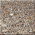
Bargate stone, Buckland church
Bargate stone is very much a local building material, seen chiefly in south-west Surrey and neighbouring parts of Sussex and Hampshire. Quarrying - from the Lower Greensand formation - started in medieval times, chiefly in the Godalming area. It was the Greensand, too, which provided the raw material for the early iron industry in Surrey - and there is certainly a range of rusty shades to be found in this sample of walling.
For a more general view of the west end of the church (where this masonry is to be found) see http://www.geograph.org.uk/photo/2380835
Image: © Stefan Czapski
Taken: 25 Apr 2011
0.02 miles
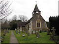
4
St Mary the Virgin, Buckland
A Grade II listed church, built around 1380 and restored by Woodyer in 1860. For listing particulars see www.historicengland.org.uk/listing/the-list/list-entry/1378123.
Image: © Ian Capper
Taken: 26 Apr 2008
0.03 miles
5
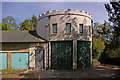
Outhouse, Buckland Court
One end of a range of outhouses of Buckland Court.
Image: © Ian Capper
Taken: 26 Apr 2008
0.04 miles
6
St Mary the Virgin, Buckland
For brief details refer to Image
Image: © Robin Webster
Taken: 24 Nov 2010
0.04 miles
8
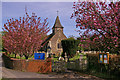
St Mary the Virgin, Buckland
A very visible church, standing adjacent to the busy A25. It has ancient origins but was heavily restored c.1860 by Henry Woodyer and is grade 2 listed.
Image: © Stephen Craven
Taken: 28 Feb 2012
0.04 miles
9
St Mary the Virgin, Buckland
A Grade II listed church, built around 1380 and restored by Woodyer in 1860. For listing particulars see www.historicengland.org.uk/listing/the-list/list-entry/1378123.
Image: © Ian Capper
Taken: 27 May 2012
0.05 miles
10
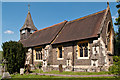
St Mary the Virgin, Buckland
A Grade II listed church, built around 1380 and restored by Woodyer in 1860. For listing particulars see www.historicengland.org.uk/listing/the-list/list-entry/1378123.
Image: © Ian Capper
Taken: 27 May 2012
0.05 miles