IMAGES TAKEN NEAR TO
Old Road, BETCHWORTH, RH3 7DT
Introduction
This page details the photographs taken nearby to Old Road, RH3 7DT by members of the Geograph project.
The Geograph project started in 2005 with the aim of publishing, organising and preserving representative images for every square kilometre of Great Britain, Ireland and the Isle of Man.

There are currently over 7.5m images from over14,400 individuals and you can help contribute to the project by visiting https://www.geograph.org.uk
Image Map
Images are licensed for reuse under creativecommons.org/licenses/by-sa/2.0
Notes
- Clicking on the map will re-center to the selected point.
- The higher the marker number, the further away the image location is from the centre of the postcode.
Image Listing (26 Images Found)
Images are licensed for reuse under creativecommons.org/licenses/by-sa/2.0
Image
Details
Distance
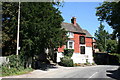
3
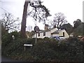
The Coach House
Converted garages next to Knowl Cottage, on Old Road. IT first appears on the 1896 1,2500 map, and would appear to have been the coach house for the adjacent Buckland Knowl, since redeveloped.
Image: © Ian Capper
Taken: 14 Jun 2020
0.02 miles
4
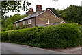
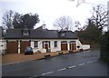
Sandpit Cottages
Victorian cottages in an old sandpit, signs of which can be seen in the background.
Image: © Ian Capper
Taken: 20 May 2012
0.02 miles
5
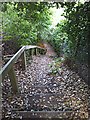
Jacob's ladder
A steep and unexpectedly encountered flight of steps between Sandpitts Cottages and 4 Old Road, on public footpath Buckland 466, which runs between Old Road and bridleway 464 connecting with Wonham Lane. There has long been a footpath along this alignment, but (as the name of the neighbouring cottages suggest) a sandpit dug next to the former main road caused the footpath to be continued down the face of the sandpit by a stairway. The path endures today, although the sandpit has long since been parcelled up into residential plots.
Image: © Hugh Craddock
Taken: 4 Aug 2013
0.02 miles
6

Old Road and Sandy Lane
View west along Old Road, Betchworth, to the junction with Sandy Lane on the left. On the right is the entrance to Knowl Cottage. Photograph is taken from just outside Image Ahead, Old Road descends through a sunken lane to Image On the left is a bus stop for the route 32 bus from Redhill to Guildford.
Image: © Hugh Craddock
Taken: 4 Aug 2013
0.02 miles
7
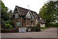
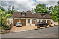
Hartsfield Lodge
Lodge to Hartsfield Manor - see Image Presumably built in the 1860s at the same time as the main house.
Image: © Ian Capper
Taken: 20 May 2012
0.06 miles
8
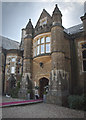
Hartsfield Manor
An old manor house now used as a hotel and conferencing centre
Image: © Kurseong Carl
Taken: 7 Mar 2010
0.06 miles
9
The 'Red Lion', Old Road, Betchworth, Surrey
'Old Road' is in fact the precursor of the more modern A25, itself now yielding place to the M25 as the fastest route east to west hereabouts.
Image: © Dr Neil Clifton
Taken: 4 Aug 2007
0.09 miles
10
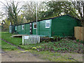
Betchworth Cricket Club pavilion
Behind the Red Lion.
Image: © Robin Webster
Taken: 24 Nov 2010
0.10 miles