IMAGES TAKEN NEAR TO
Rectory Lane, BETCHWORTH, RH3 7BL
Introduction
This page details the photographs taken nearby to Rectory Lane, RH3 7BL by members of the Geograph project.
The Geograph project started in 2005 with the aim of publishing, organising and preserving representative images for every square kilometre of Great Britain, Ireland and the Isle of Man.

There are currently over 7.5m images from over14,400 individuals and you can help contribute to the project by visiting https://www.geograph.org.uk
Image Map
Images are licensed for reuse under creativecommons.org/licenses/by-sa/2.0
Notes
- Clicking on the map will re-center to the selected point.
- The higher the marker number, the further away the image location is from the centre of the postcode.
Image Listing (66 Images Found)
Images are licensed for reuse under creativecommons.org/licenses/by-sa/2.0
Image
Details
Distance
1

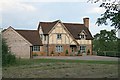
Oak House
A house in Rectory Lane, extended from a 17th century cottage. The North Downs can be seen behind.
Image: © Ian Capper
Taken: 10 Feb 2008
0.01 miles
2

Rectory Lane
Country lane north of Buckland lined with attractive scattered cottages and houses.
Image: © Colin Smith
Taken: 10 Jul 2011
0.01 miles
3
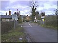
Automatic Half-Barrier Level Crossing
Image: © Martyn Davies
Taken: 13 Jan 2008
0.04 miles
5
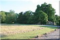
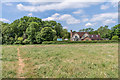
Rectory Green
Part of the area of Rectory Lane waste. It is at its deepest here, between Oak House (the drive to which crosses the common and from which the photograph is taken) and Stonecrop, known as Rectory Green. This part is mown and kept open.
Image: © Hugh Craddock
Taken: 24 Jun 2014
0.05 miles
6
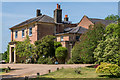
Glebe House
Thought to date from around 1780, this house once served as the rectory for Buckland Church, until 1924, when the incumbent moved to what is now the Old Rectory on Buckland Green.
Image: © Ian Capper
Taken: 27 May 2020
0.05 miles
7
Stonecrop, Rectory Green
A probably C17 house, greatly restored, enlarged and extended, on the east side of Rectory Lane, and separated from the road by a broad swathe of roadside waste, known as Rectory Green, partly visible in the foreground.
Image: © Hugh Craddock
Taken: 24 Jun 2014
0.05 miles
8
Glebe House
Thought to date from around 1780, this house once served as the rectory for Buckland Church, until 1924, when the incumbent moved to what is now the Old Rectory on Buckland Green.
Image: © Ian Capper
Taken: 21 Mar 2010
0.06 miles
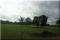
9

Field off Rectory Lane
On the left is the Guildford - Redhill railway.
Image: © Ian Capper
Taken: 21 Mar 2010
0.06 miles
10
Stonecrop
The rear of Stonecrop, a house on Rectory Lane built in 2006 replacing a previous building on the site. Seen from the footpath that links Rectory Lane with Lawrence Lane.
Image: © Ian Capper
Taken: 27 May 2020
0.06 miles