IMAGES TAKEN NEAR TO
Reigate Road, BETCHWORTH, RH3 7BG
Introduction
This page details the photographs taken nearby to Reigate Road, RH3 7BG by members of the Geograph project.
The Geograph project started in 2005 with the aim of publishing, organising and preserving representative images for every square kilometre of Great Britain, Ireland and the Isle of Man.

There are currently over 7.5m images from over14,400 individuals and you can help contribute to the project by visiting https://www.geograph.org.uk
Image Map
Images are licensed for reuse under creativecommons.org/licenses/by-sa/2.0
Notes
- Clicking on the map will re-center to the selected point.
- The higher the marker number, the further away the image location is from the centre of the postcode.
Image Listing (39 Images Found)
Images are licensed for reuse under creativecommons.org/licenses/by-sa/2.0
Image
Details
Distance
2
The Old Cottage and Jolly Farmers Cottage
The Old Cottage (on the left) dates from the late 17th century and is grade II listed - for listing particulars see www.historicengland.org.uk/listing/the-list/list-entry/1028758.
Jolly Farmers Cottage (on the right) is thought to date from the 18th century. It was once a pub (before being replaced by the pub of the same name built next door in the 1920s/30s - see Image). Old maps show it with its former name, The Tap, the name presumably linked to Tap Wood situated on the other side of Reigate Road, now the site of a sand quarry (see Image).
Image: © Ian Capper
Taken: 26 Jun 2010
0.02 miles
3
Jolly Farmers, old and new
The building on the left is Jolly Farmers Cottage, thought to date from the 18th century, and was the original Jolly Farmers pub Jolly Farmers Cottage (on the right) is thought to date from the 18th century. Old maps show it with its former name, The Tap.
Beyond it is the current Jolly Farmers, a 1920s/30s building, which styles itself as a "deli-pub and restaurant", housing a delicatessen/farm shop as well as a bar and restaurant (see Image).
Image: © Ian Capper
Taken: 29 Aug 2011
0.02 miles
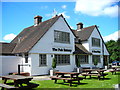
5
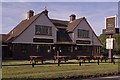
The Jolly Farmers
Housed in a 1920s/30s building, it replaces a pub of the same name next door, now a cottage (see Image). It now styles itself as a "deli-pub and restaurant", housing a delicatessen/farm shop as well as a bar and restaurant.
Image: © Ian Capper
Taken: 29 Aug 2011
0.03 miles
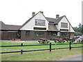
6

The Jolly Farmers
Housed in a 1920s/30s building, it replaces a pub of the same name next door, now a cottage (see Image). It now styles itself as a "deli-pub and restaurant", housing a delicatessen/farm shop as well as a bar and restaurant.
Image: © Ian Capper
Taken: 24 Jul 2010
0.04 miles
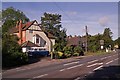
7
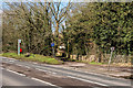
Reigate Road
The A25 Reigate Road between Reigate and Buckland. In the background is a section of the old Reigate - Dorking road, in use until superseded by the current road in the 1920s or 1930s,
Image: © Ian Capper
Taken: 4 Mar 2016
0.04 miles
9
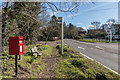
Reigate Road
Looking along the A25 Reigate Road with the former Jolly Farmers, now named The Pheasant. On the left is the post box in Image
Image: © Ian Capper
Taken: 4 Mar 2016
0.04 miles
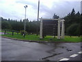
10
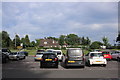
Car Park at the Pheasant at Buckland
This is the car park to the east of the well known pub/restaurant at Buckland on the A25 Reigate Rd just west of Reigate.
Image: © Nigel Mykura
Taken: 5 Jul 2019
0.05 miles