IMAGES TAKEN NEAR TO
Snower Hill Road, BETCHWORTH, RH3 7AF
Introduction
This page details the photographs taken nearby to Snower Hill Road, RH3 7AF by members of the Geograph project.
The Geograph project started in 2005 with the aim of publishing, organising and preserving representative images for every square kilometre of Great Britain, Ireland and the Isle of Man.

There are currently over 7.5m images from over14,400 individuals and you can help contribute to the project by visiting https://www.geograph.org.uk
Image Map
Images are licensed for reuse under creativecommons.org/licenses/by-sa/2.0
Notes
- Clicking on the map will re-center to the selected point.
- The higher the marker number, the further away the image location is from the centre of the postcode.
Image Listing (176 Images Found)
Images are licensed for reuse under creativecommons.org/licenses/by-sa/2.0
Image
Details
Distance
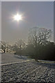
1
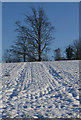
Snowy field
Tractor treads leading to a tree in a snowy field south of Betchworth.
Image: © Ian Capper
Taken: 20 Dec 2009
0.05 miles
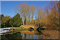
3
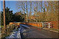
Betchworth Bridge
Spanning the River Mole, this single track bridge was built in 1842 and strengthened and refurbished in 1993.
Through the trees can be seen part of the Grade II* listed Betchworth House. For listing particulars see www.historicengland.org.uk/listing/the-list/list-entry/1028786.
Image: © Ian Capper
Taken: 20 Dec 2009
0.10 miles
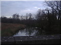
4
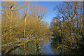
River Mole at Betchworth
Looking upstream from Betchworth Bridge.
Image: © Ian Capper
Taken: 20 Dec 2009
0.11 miles
5
Betchworth Bridge
Spanning the River Mole, this bridge was built in 1842 and strengthened and refurbished in 1993.
Image: © Ian Capper
Taken: 20 Dec 2009
0.11 miles
6
Bridge over the River Mole, Betchworth
Image: © David Howard
Taken: 30 Jan 2012
0.12 miles
7
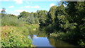
River Mole at Betchworth
The view upstream from Betchworth Bridge.
The Oxford Dictionary of English Place Names suggests that the name Mole comes either from the Latin mola (a mill) or is derived from Molesey, where the Mole flows into the Thames after its 50 mile journey from Horsham.
Image: © Mark Percy
Taken: 13 Sep 2018
0.12 miles
8
Winter sun
Winter sun over a snow covered field south of Betchworth, forming a background to some fine oak trees.
Image: © Ian Capper
Taken: 20 Dec 2009
0.12 miles
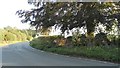
9
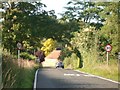
The southern approach to Betchworth
looking north along Snowerhill Road
Image: © Andrew Longton
Taken: 20 Sep 2005
0.12 miles
10
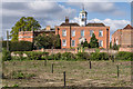
Betchworth House
The grade II* listed Betchworth House dates partly from the late 17th century (the brick faced section in the centre of this photo, with the cupola) and partly from the early 19th century (the partly seen block behind). It was originally built for the Freeman family, a member of which, Sir Ralph Freeman, had purchased the estate in 1634. The estate was later acquired in 1816 by the Right Honourable Henry Goulburn, and has remained in the family ever since, with the present owner, Lord Hamilton of Dalzell, being a direct descendant of Henry. The gardens were designed by Humphrey Repton, the late 18th century garden designer, and are considered to be an excellent example of his work.
For listing particulars of the house, see www.historicengland.org.uk/listing/the-list/list-entry/1028786.
Image: © Ian Capper
Taken: 18 Apr 2014
0.16 miles