IMAGES TAKEN NEAR TO
Albany Close, REIGATE, RH2 9PP
Introduction
This page details the photographs taken nearby to Albany Close, RH2 9PP by members of the Geograph project.
The Geograph project started in 2005 with the aim of publishing, organising and preserving representative images for every square kilometre of Great Britain, Ireland and the Isle of Man.

There are currently over 7.5m images from over14,400 individuals and you can help contribute to the project by visiting https://www.geograph.org.uk
Image Map
Images are licensed for reuse under creativecommons.org/licenses/by-sa/2.0
Notes
- Clicking on the map will re-center to the selected point.
- The higher the marker number, the further away the image location is from the centre of the postcode.
Image Listing (71 Images Found)
Images are licensed for reuse under creativecommons.org/licenses/by-sa/2.0
Image
Details
Distance
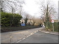
1
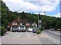
The Yew Tree public house, with Reigate Hill in the background
Reigate Hill can be seen leading off to the right and Reigate transmitter mast can be seen poking out of the trees above.
Image: © Hywel Williams
Taken: 19 Jul 2005
0.08 miles
3
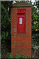
Edwardian postbox
With an OS benchmark in the pillar as an added bonus!
Image: © Ian Capper
Taken: 21 Apr 2008
0.09 miles
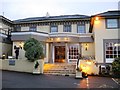
5
Reigate Hill at the junction of Raglan Road
Looking towards the Reigate Manor Hotel
Image: © David Howard
Taken: 29 Mar 2015
0.10 miles
6
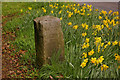
Milestone on Reigate Hill
Situated on the A217 north out of Reigate (see Image), this limestone milestone dates from the early 19th century and is Grade II listed. On the south face (visible) is written London 20, Sutton 9, and on the east face Brighton 31 5/8, Reigate 5/8.
Image: © Ian Capper
Taken: 15 Mar 2008
0.11 miles
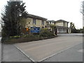
7
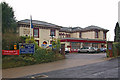
Reigate Manor Hotel
A Best Western Hotel on Reigate Hill. Originally a Georgian Manor House called The Brokes, and shown as such on maps of 1874 and 1897, much extended it subsequently became the Reigate Hill Hotel (see http://www.francisfrith.com/reigate/photos/hill-hotel-1935_R20001/ for 1935 photo), a name which still appears on a map of 1947. It was subsequently renamed the Reigate Manor Hotel.
Image: © Ian Capper
Taken: 12 Dec 2009
0.11 miles
8
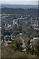
Reigate Hill from Reigate Hill
Looking down Reigate Hill (the road) from the slopes of Reigate Hill (the hill).
On the bottom right is the Reigate Manor Hotel (see Image), on the left hand edge of the photo around 2/3rds of the way up is St Marks Church (see Image) and towards the right hand side and slightly higher is the green roofed tower of the Church of the Holy Family (see Image). The complex roofed building further up toward the left hand edge is the Town Hall (see Image) with the top of Reigate Priory (see Image) just visible beyond. Behind this is Priory Park with the wooded Park Hill beyond.
In the background is the Sussex Weald with the line of the South Downs just visible in the far distance on the right.
Image: © Ian Capper
Taken: 2 Apr 2013
0.11 miles
9
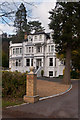
Cleveland, Beech Road
An impressive Victorian mansion in the Underhill area on Reigate Hill, now divided into flats. Locally listed.
Image: © Ian Capper
Taken: 21 Jan 2012
0.11 miles
10
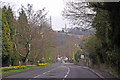
Reigate Hill
Reigate Hill is the street name assigned to this section of the A217 out of Reigate leading up to Junction 8 of the M25. It is also the hill itself on the North Downs, as seen in the background with the television masts.
On the left can be seen an early 19th century milestone (see Image).
Image: © Ian Capper
Taken: 15 Mar 2008
0.11 miles