IMAGES TAKEN NEAR TO
West Street, REIGATE, RH2 9JZ
Introduction
This page details the photographs taken nearby to West Street, RH2 9JZ by members of the Geograph project.
The Geograph project started in 2005 with the aim of publishing, organising and preserving representative images for every square kilometre of Great Britain, Ireland and the Isle of Man.

There are currently over 7.5m images from over14,400 individuals and you can help contribute to the project by visiting https://www.geograph.org.uk
Image Map
Images are licensed for reuse under creativecommons.org/licenses/by-sa/2.0
Notes
- Clicking on the map will re-center to the selected point.
- The higher the marker number, the further away the image location is from the centre of the postcode.
Image Listing (147 Images Found)
Images are licensed for reuse under creativecommons.org/licenses/by-sa/2.0
Image
Details
Distance
1
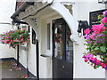
Black Horse, Reigate
Hanging floral baskets and distinctive black horse heads on the walls at this road house in western Reigate.
Image: © Colin Smith
Taken: 10 Jul 2011
0.00 miles
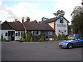
2
The Black Horse
Or is it the White Horse?
The Black Horse dates from around 1760, built by a Mr John Fist. Seen here after three days of heavy snowfall.
Image: © Ian Capper
Taken: 3 Dec 2010
0.01 miles
3
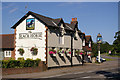
The Black Horse, West Street
Dating from around 1760, built by a Mr John Fist.
Image: © Ian Capper
Taken: 15 Jun 2008
0.01 miles
4
The 'Black Horse', West Street, Reigate
Excellent pub with a good variety of food and a choice of real ales.
Image: © Dr Neil Clifton
Taken: 17 Oct 2007
0.01 miles
5
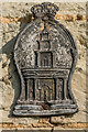
Fire insurance mark
Royal Exchange Assurance fire insurance mark on the wall of Heath Cottage on Flanchford Road (see Image).
Image: © Ian Capper
Taken: 26 Apr 2021
0.02 miles
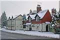
6
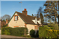
Heath Cottage
18th Century cottage on Flanchford Road. Grade II listed - see www.historicengland.org.uk/listing/the-list/list-entry/1029107
Image: © Ian Capper
Taken: 31 Mar 2017
0.02 miles
7
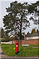
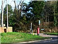
Colley Lane postbox
Postbox at the junction of Colley Lane with West Street, with dandelions providing a contrasting colour.
Image: © Ian Capper
Taken: 2 Apr 2011
0.02 miles
8
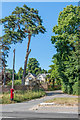
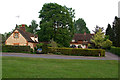
Colley Lane
Junction of Colley Lane with West Street. In the background is The Manor. (This would appear to be its official name according to the Royal Mail and Reigate and Banstead District Council, as well as being the name on the gate, but it is marked on maps as Colley Manor, the name of an earlier building where Colley Manor Drive is now, around 200m to the west.) Older maps mark it as Colley Cottage.
Image: © Ian Capper
Taken: 30 May 2020
0.02 miles
10
Heath Cottage and Heath Lodge
Heath Cottage (on the left) dates from the 18th century. It received the name Heath Cottage in 1942. Grade II listed - for listing particulars see www.historicengland.org.uk/listing/the-list/list-entry/1029107.
Heath Lodge (on the right) dates from the 1960s.
Image: © Ian Capper
Taken: 24 Apr 2011
0.02 miles