IMAGES TAKEN NEAR TO
Colley Manor Drive, REIGATE, RH2 9JS
Introduction
This page details the photographs taken nearby to Colley Manor Drive, RH2 9JS by members of the Geograph project.
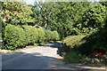
The Geograph project started in 2005 with the aim of publishing, organising and preserving representative images for every square kilometre of Great Britain, Ireland and the Isle of Man.

There are currently over 7.5m images from over14,400 individuals and you can help contribute to the project by visiting https://www.geograph.org.uk
Image Map (Loading...)


Getting Data...Please wait
Leaflet Map data © OpenStreetMap
Images are licensed for reuse under creativecommons.org/licenses/by-sa/2.0
Notes
- Clicking on the map will re-center to the selected point.
- The higher the marker number, the further away the image location is from the centre of the postcode.
Image Listing (129 Images Found)
Images are licensed for reuse under creativecommons.org/licenses/by-sa/2.0
Image
Details
Distance
1
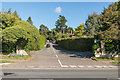
Colley Manor Drive
A road of large houses first developed in the late 1930s on the site of Colley Manor, the walls and pillars of whose grounds can be seen either side of the entrance - see Image for a close up of these.
Image: © Ian Capper
Taken: 8 Oct 2015
0.05 miles
2
Longview
House on Colley Manor Drive, a road of large houses first developed in the late 1930s on the site of Colley Manor (although this access is off Clifton's Lane).
Image: © Ian Capper
Taken: 13 Apr 2020
0.06 miles
3
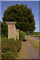
Colley Manor Drive
These ornate pillars form part of the frontage to Colley Manor Drive on to the A25 Buckland Road. They date from around 1840 and are locally listed.
Image: © Ian Capper
Taken: 24 May 2009
0.07 miles
4
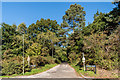
Clifton's Lane
Lane off Buckland Road. At the upper end it turns into a bridleway leading up to the North Downs.
Image: © Ian Capper
Taken: 8 Oct 2015
0.08 miles
5
Reigate: Clifton's Lane
Looking north. This is a byway open to all traffic, but there is no through road at the northern end.
Image: © Dr Neil Clifton
Taken: 26 Aug 2013
0.08 miles
6
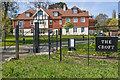
The Croft
Block of 8 apartments completed in 2020, replacing a former care home of the same name, which had been housed in building dating from the early 20th Century.
Image: © Ian Capper
Taken: 26 Apr 2021
0.08 miles
7
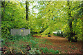
Footpath 475 nears Clifton's Lane
With a garden refuse heap and a small electricity sub-station at the left, the footpath follows the leafy way under the arched branches.
Image: © Robin Webster
Taken: 27 Oct 2010
0.08 miles
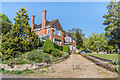
8
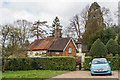
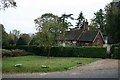
Little Everest
16th century grade II listed cottage on Clifton's Lane. For listing particulars see www.historicengland.org.uk/listing/the-list/list-entry/1241693.
Image: © Ian Capper
Taken: 23 Mar 2014
0.08 miles
9
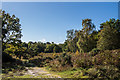
Reigate Heath
Area of Reigate Heath south of Buckland Road.
Image: © Ian Capper
Taken: 8 Oct 2015
0.09 miles
10
Reigate Heath outside Little Everest
The grass outside Little Everest marks the northern limit of Reigate Heath.
Image: © Hugh Craddock
Taken: 19 Oct 2009
0.09 miles