IMAGES TAKEN NEAR TO
Colley Lane, REIGATE, RH2 9JA
Introduction
This page details the photographs taken nearby to Colley Lane, RH2 9JA by members of the Geograph project.
The Geograph project started in 2005 with the aim of publishing, organising and preserving representative images for every square kilometre of Great Britain, Ireland and the Isle of Man.

There are currently over 7.5m images from over14,400 individuals and you can help contribute to the project by visiting https://www.geograph.org.uk
Image Map
Images are licensed for reuse under creativecommons.org/licenses/by-sa/2.0
Notes
- Clicking on the map will re-center to the selected point.
- The higher the marker number, the further away the image location is from the centre of the postcode.
Image Listing (102 Images Found)
Images are licensed for reuse under creativecommons.org/licenses/by-sa/2.0
Image
Details
Distance
1
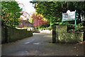
Entrance to Reigate Beaumont Care Home
On Colley Lane.
Image: © Robin Webster
Taken: 27 Oct 2010
0.04 miles
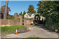
2
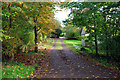
Drive to Old Colley Farm
A turning off Colley Lane.
Image: © Robin Webster
Taken: 27 Oct 2010
0.09 miles
3
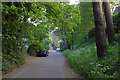
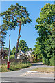
Colley Lane
Looking down Colley Lane towards its junction with West Street in the background.
Image: © Ian Capper
Taken: 24 Apr 2011
0.09 miles
4
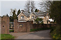
The Manor, Colley Lane
House on Colley Lane near its junction with West Street. (This would appear to be its official name according to the Royal Mail and Reigate and Banstead District Council, as well as being the name on the gate, but it is marked on maps as Colley Manor, the name of an earlier building where Colley Manor Drive is now, around 200m to the west.) Older maps mark it as Colley Cottage.
Image: © Ian Capper
Taken: 2 Apr 2011
0.11 miles
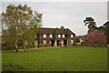
5
The Manor House
This building originally dates from around 1600, although it was extended in the 19th century. Grade II listed - for listing particulars see www.historicengland.org.uk/listing/the-list/list-entry/1241449. It is now divided into four residences.
Image: © Ian Capper
Taken: 24 Apr 2011
0.11 miles
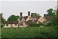
6
Pavilion Cottages
Grade II listed former cricket pavilion with two cottages, designed in 1937 by Sir Edwin and Robert Lutyens for Sir William Mallinson of Pine End (a large house nearby, now a nursing home). Converted into two dwellings in around 1950. For listing particulars, see www.historicengland.org.uk/listing/the-list/list-entry/1029048.
Image: © Ian Capper
Taken: 26 Apr 2008
0.12 miles
7
Colley Lane
Side road off West Street. In the background is The Manor. (This would appear to be its official name according to the Royal Mail and Reigate and Banstead District Council, as well as being the name on the gate, but it is marked on maps as Colley Manor, the name of an earlier building where Colley Manor Drive is now, around 200m to the west.) Older maps mark it as Colley Cottage.
Image: © Ian Capper
Taken: 8 Oct 2015
0.13 miles
9
Colley Lane
Junction of Colley Lane with West Street. In the background is The Manor. (This would appear to be its official name according to the Royal Mail and Reigate and Banstead District Council, as well as being the name on the gate, but it is marked on maps as Colley Manor, the name of an earlier building where Colley Manor Drive is now, around 200m to the west.) Older maps mark it as Colley Cottage.
Image: © Ian Capper
Taken: 30 May 2020
0.14 miles
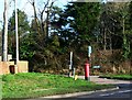
10
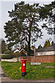
Colley Lane postbox
Postbox at the junction of Colley Lane with West Street, with dandelions providing a contrasting colour.
Image: © Ian Capper
Taken: 2 Apr 2011
0.14 miles