IMAGES TAKEN NEAR TO
Nutley Lane, REIGATE, RH2 9HP
Introduction
This page details the photographs taken nearby to Nutley Lane, RH2 9HP by members of the Geograph project.
The Geograph project started in 2005 with the aim of publishing, organising and preserving representative images for every square kilometre of Great Britain, Ireland and the Isle of Man.

There are currently over 7.5m images from over14,400 individuals and you can help contribute to the project by visiting https://www.geograph.org.uk
Image Map
Images are licensed for reuse under creativecommons.org/licenses/by-sa/2.0
Notes
- Clicking on the map will re-center to the selected point.
- The higher the marker number, the further away the image location is from the centre of the postcode.
Image Listing (585 Images Found)
Images are licensed for reuse under creativecommons.org/licenses/by-sa/2.0
Image
Details
Distance
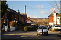
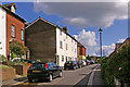
1
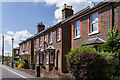
Nutley Lane
Victorian terrace along the original route into Reigate from the north.
Image: © Ian Capper
Taken: 25 May 2013
0.01 miles
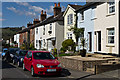
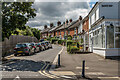
2
Nutley Lane
Looking along Nutley Lane with Colley Hill in the background.
Image: © Ian Capper
Taken: 27 Apr 2013
0.01 miles
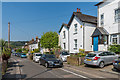
3
Nutley Lane
Looking along Nutley Lane with Colley Hill in the background.
Image: © Ian Capper
Taken: 27 Apr 2013
0.01 miles
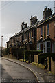
4
Nutley Lane
Lat Victorian housing in Nutley Lane.
Image: © Ian Capper
Taken: 24 Apr 2020
0.01 miles
5
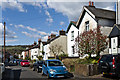
Nutley Lane, Reigate
Of the countless times I have been in, or through, Reigate, this was the first time that I had ventured up Nutley Lane. At this point, the lane is a one-way street. I was amazed to see the view towards Colley Hill, which can be accessed from a continuation of this lane (Pilgrims' Way).
Image: © Peter Trimming
Taken: 9 Feb 2010
0.02 miles
6
Nutley Lane
Late Victorian terrace viewed against a low winter sun.
Image: © Ian Capper
Taken: 14 Dec 2013
0.02 miles
7
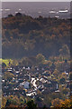
Nutley Lane
The sun glinting off the roofs of houses and cars in Nutley Lane, Reigate. In the bottom left hand corner of the photo is St Philips Church. Across the middle of the photo is Priory Park and the wooded Park Hill, with buildings around Gatwick Airport in the far distance (the airport control tower is just visible on the far left of the photo).
Image: © Ian Capper
Taken: 2 Nov 2012
0.02 miles
8
Nutley Lane
Looking along Nutley Lane with Colley Hill in the background.
Image: © Ian Capper
Taken: 27 Apr 2013
0.02 miles
9
Ion Place
Ion Place is the name of the large building in the centre of the photo, dating from 1887. It originally housed a row of shops, with the barbers in one of them only ceasing to trade in the 1990s. Part of the Nutley Lane homezone (see Image).
Image: © Ian Capper
Taken: 25 May 2008
0.02 miles
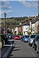
10
Nutley Lane
Looking south along Nutley Lane from by the Yorke Road/Beaufort Road crossroads.
The building on the right, now housing a hairdressers' salon, was once one of a number of small shops along the road.
Image: © Ian Capper
Taken: 13 Jun 2020
0.03 miles