IMAGES TAKEN NEAR TO
Yorke Road, REIGATE, RH2 9HG
Introduction
This page details the photographs taken nearby to Yorke Road, RH2 9HG by members of the Geograph project.
The Geograph project started in 2005 with the aim of publishing, organising and preserving representative images for every square kilometre of Great Britain, Ireland and the Isle of Man.

There are currently over 7.5m images from over14,400 individuals and you can help contribute to the project by visiting https://www.geograph.org.uk
Image Map
Images are licensed for reuse under creativecommons.org/licenses/by-sa/2.0
Notes
- Clicking on the map will re-center to the selected point.
- The higher the marker number, the further away the image location is from the centre of the postcode.
Image Listing (602 Images Found)
Images are licensed for reuse under creativecommons.org/licenses/by-sa/2.0
Image
Details
Distance
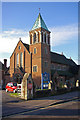
1
The Catholic Church of the Holy Trinity, Reigate
Image: © David Howard
Taken: 17 Jan 2016
0.01 miles
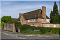
2
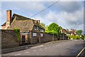
The Wall House
1920s/early 1930s house in Yorke Road, now housing a doctors' surgery.
Image: © Ian Capper
Taken: 15 Jun 2013
0.02 miles
3
The Wall House
1920s/early 1930s house in Yorke Road, now housing a doctors' surgery. In the background is the tower of the Church of the Holy Family.
Image: © Ian Capper
Taken: 25 May 2013
0.02 miles
4
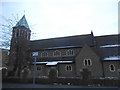
Church of the Holy Family
The Roman Catholic Church for Reigate situated in Yorke Road, consecrated in 1938.
Image: © Ian Capper
Taken: 11 Dec 2007
0.02 miles
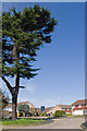
5
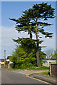
Cedar
A Cedar on Yorke Road where it is met by Burnham Drive.
Image: © Ian Capper
Taken: 6 May 2013
0.02 miles
6
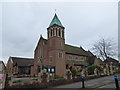
R.C. Church of the Holy Family, Yorke Road
Image: © Basher Eyre
Taken: 30 Jan 2017
0.02 miles
7
Yorke Road
1970s houses in Burnham Drive backing on to Yorke Road.
Image: © Ian Capper
Taken: 27 Apr 2013
0.02 miles
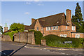
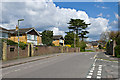
8
Burnham Drive
A small estate off Yorke Road built in the 1970s. In the background, on the other side of Yorke Road, is the Church of the Holy Family.
Image: © Ian Capper
Taken: 27 Apr 2013
0.02 miles
9
The Wall House
1920s/early 1930s house in Yorke Road, now housing a doctors' surgery.
Image: © Ian Capper
Taken: 3 Jun 2013
0.02 miles
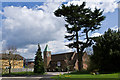
10
Burnham Drive
A large Cedar tree dominates the entrance to Burnham Drive, a 1970s development off Yorke Road.
Image: © Ian Capper
Taken: 19 Mar 2011
0.03 miles