IMAGES TAKEN NEAR TO
High Street, REIGATE, RH2 9BG
Introduction
This page details the photographs taken nearby to High Street, RH2 9BG by members of the Geograph project.
The Geograph project started in 2005 with the aim of publishing, organising and preserving representative images for every square kilometre of Great Britain, Ireland and the Isle of Man.

There are currently over 7.5m images from over14,400 individuals and you can help contribute to the project by visiting https://www.geograph.org.uk
Image Map
Images are licensed for reuse under creativecommons.org/licenses/by-sa/2.0
Notes
- Clicking on the map will re-center to the selected point.
- The higher the marker number, the further away the image location is from the centre of the postcode.
Image Listing (973 Images Found)
Images are licensed for reuse under creativecommons.org/licenses/by-sa/2.0
Image
Details
Distance
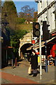
1
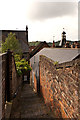
Crown Steps
A narrow stepped path linking Market Square and Castle Walk. In the background is the top of the Old Town Hall.
Image: © Ian Capper
Taken: 19 May 2012
0.00 miles
2
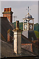
Chimneys and a clock
Varied roof objects seen from the path above Reigate Tunnel. The nearest chimney is on the roof of The Market and the two chimneys behind are on Lloyds Bank (for both see Image Beyond is the clock tower and cupola on the Old Town Hall (see Image).
Image: © Ian Capper
Taken: 19 May 2012
0.00 miles
5
Tunnel Road, Reigate, Surrey
Looking towards the tunnel, which runs under the site of Reigate Castle. Tunnel Road is now only open to pedestrians and cyclists.
Image: © Peter Trimming
Taken: 14 Jan 2012
0.01 miles
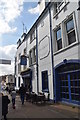
6
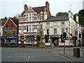
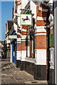
2 - 4a High Street
From right to left:
2 (The Market Hotel) is locally listed, dating from the late 18th century.
4 (Lloyds TSB) is locally listed, dating from the late 19th century.
4a (Carphone Warehouse) is grade II listed, dating from the early 17th century - for listing particulars see www.historicengland.org.uk/listing/the-list/list-entry/1377947. For many years it was occupied by La Trobes, a gift and toy shop that had been trading in Reigate from 1911 to 1980, at first on the opposite side of the High Street, before moving to these premises. The previous occupants had been Eames Outfitters, hence the words on the front.
On the right is Tunnel Road, leading to Reigate Tunnel (see Image).
Image: © Ian Capper
Taken: 4 May 2009
0.01 miles
7
2 - 4a High Street
From right to left:
2 (The Market Hotel) is locally listed, dating from the late 18th century.
4 (Lloyds TSB) is locally listed, dating from the late 19th century.
4a (Carphone Warehouse) is grade II listed, dating from the early 17th century - for listing particulars see www.historicengland.org.uk/listing/the-list/list-entry/1377947. For many years it was occupied by La Trobes, a gift and toy shop that had been trading in Reigate from 1911 to 1980, at first on the opposite side of the High Street, before moving to these premises. The previous occupants had been Eames Outfitters, hence the words on the front.
6 (partly hidden by the tree) is probably of 18th century origin and is grade II listed - see www.historicengland.org.uk/listing/the-list/list-entry/1029121.
On the right is Tunnel Road, leading to Reigate Tunnel (see Image).
Image: © Ian Capper
Taken: 27 May 2012
0.01 miles
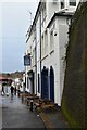
8
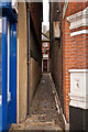
Crown Passage
Narrow passage off High Street, leading to Crown Steps (see Image).
Image: © Ian Capper
Taken: 8 Apr 2012
0.01 miles
9
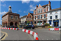
Reigate Town Centre
The junction of Bell Street with High Street and Church Street, with the Old Town Hall on the left (see Image and various premises on the right and Image for closer view). The barriers are for a temporary cycle lane that had been installed by Surrey County Council a couple of days earlier, on 3 July 2020, with the aim of encouraging cycling in Reigate and widening the pavements for pedestrians. Unfortunately the idea, admirable though it might have seemed, failed to recognise the frequent traffic jams in Reigate which occur with two lanes through the one way system, so potentially worsened with just one, and also the impact on deliveries and general access to the town centre. It was therefore quickly realised that rather than make the area more attractive to shoppers, it would instead have the opposite effect of damaging businesses by keeping them away. As a result, instead of being a 3 month experiment as planned, it lasted less than 3 days, the barriers being removed on 6 July, the day after this photo was taken.
Image: © Ian Capper
Taken: 5 Jul 2020
0.01 miles
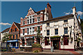
10
Lloyds Bank
The frontage of Lloyds Bank in High Street.
Image: © Ian Capper
Taken: 18 Apr 2014
0.01 miles