Reigate Town Centre
Introduction
The photograph on this page of Reigate Town Centre by Ian Capper as part of the Geograph project.
The Geograph project started in 2005 with the aim of publishing, organising and preserving representative images for every square kilometre of Great Britain, Ireland and the Isle of Man.

There are currently over 7.5m images from over 14,400 individuals and you can help contribute to the project by visiting https://www.geograph.org.uk
Reigate Town Centre
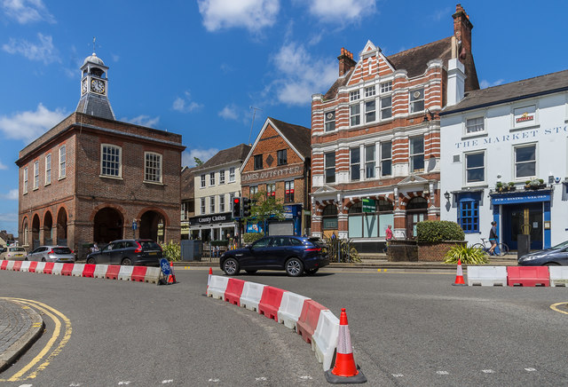
Image: © Ian Capper Taken: 5 Jul 2020
The junction of Bell Street with High Street and Church Street, with the Old Town Hall on the left (see Image and various premises on the right and Image for closer view). The barriers are for a temporary cycle lane that had been installed by Surrey County Council a couple of days earlier, on 3 July 2020, with the aim of encouraging cycling in Reigate and widening the pavements for pedestrians. Unfortunately the idea, admirable though it might have seemed, failed to recognise the frequent traffic jams in Reigate which occur with two lanes through the one way system, so potentially worsened with just one, and also the impact on deliveries and general access to the town centre. It was therefore quickly realised that rather than make the area more attractive to shoppers, it would instead have the opposite effect of damaging businesses by keeping them away. As a result, instead of being a 3 month experiment as planned, it lasted less than 3 days, the barriers being removed on 6 July, the day after this photo was taken.
Images are licensed for reuse under creativecommons.org/licenses/by-sa/2.0
Image Location
Latitude
51.237782
Longitude
-0.206051