IMAGES TAKEN NEAR TO
High Street, REIGATE, RH2 9AE
Introduction
This page details the photographs taken nearby to High Street, RH2 9AE by members of the Geograph project.
The Geograph project started in 2005 with the aim of publishing, organising and preserving representative images for every square kilometre of Great Britain, Ireland and the Isle of Man.

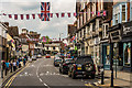
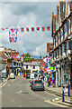
There are currently over 7.5m images from over14,400 individuals and you can help contribute to the project by visiting https://www.geograph.org.uk
Image Map
Images are licensed for reuse under creativecommons.org/licenses/by-sa/2.0
Notes
- Clicking on the map will re-center to the selected point.
- The higher the marker number, the further away the image location is from the centre of the postcode.
Image Listing (979 Images Found)
Images are licensed for reuse under creativecommons.org/licenses/by-sa/2.0
Image
Details
Distance
1
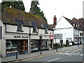
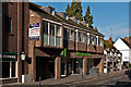
53/53a High Street
Grade II listed building originally dating from around 1500 - for listing particulars see www.historicengland.org.uk/listing/the-list/list-entry/1029125. Beyond is the Bulls Head pub (see Image).
Image: © Ian Capper
Taken: 3 May 2009
0.00 miles
2
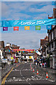
High Street - ready for the Olympic Torch
High Street with a London Olympics 2012 banner, parking restrictions and crowd barriers in place, in readiness for the passing of the Olympic Torch later that day.
Image: © Ian Capper
Taken: 20 Jul 2012
0.01 miles
3
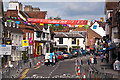
Reigate High Street
Bedecked in flags for St George's Day.
Image: © Ian Capper
Taken: 26 Apr 2008
0.01 miles
4
High Street - ready for the Olympic Torch
High Street with London Olympics 2012 banners, parking restrictions and crowd barriers in place, in readiness for the passing of the Olympic Torch later that day.
Image: © Ian Capper
Taken: 20 Jul 2012
0.01 miles
5
High Street
High Street bedecked with Union Flags in celebration of Queen Elizabeth II's official 90th birthday.
Image: © Ian Capper
Taken: 11 Jun 2016
0.01 miles
6
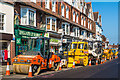
Resurfacing plant
Road resurfacing plant parked in High Street, in preparation for a major resurfacing of the Reigate one way system (of High Street, London Road, Castlefield Road, Church Street, Bancroft Road and Bell Street).
Image: © Ian Capper
Taken: 18 May 2014
0.01 miles
7
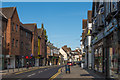
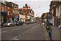
High Street
Looking west along High Street, with Priory House (see Image) on the left.
Image: © Ian Capper
Taken: 3 Aug 2014
0.01 miles
8
High Street
High Street adorned with flags in commemoration of Queen Elizabeth II's Platinum Jubilee.
Image: © Ian Capper
Taken: 31 May 2022
0.01 miles
9
M&S Simply Food
Built on the site of the Congregational Church, demolished in 1973. The shop was originally a Budgen supermarket, but was taken over by Marks and Spencer in the 1990s following the opening of Safeways (now Morrisons) - see Image
Image: © Ian Capper
Taken: 7 May 2012
0.01 miles
10
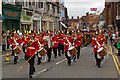
Armed Forces Day 2011 Parade in Reigate High Street
As part of the commemoration of Armed Forces Day, the 2nd Battalion of The Princess of Wales's Royal Regiment, recently returned from Afghanistan, marched through Reigate High Street, which was bedecked with Union Flags for the occasion. Leading the parade was the Regiment's own ceremonial band, the Kohima Band.
Image: © Ian Capper
Taken: 25 Jun 2011
0.01 miles