IMAGES TAKEN NEAR TO
Sandy Lane, REIGATE, RH2 8QU
Introduction
This page details the photographs taken nearby to Sandy Lane, RH2 8QU by members of the Geograph project.
The Geograph project started in 2005 with the aim of publishing, organising and preserving representative images for every square kilometre of Great Britain, Ireland and the Isle of Man.

There are currently over 7.5m images from over14,400 individuals and you can help contribute to the project by visiting https://www.geograph.org.uk
Image Map
Images are licensed for reuse under creativecommons.org/licenses/by-sa/2.0
Notes
- Clicking on the map will re-center to the selected point.
- The higher the marker number, the further away the image location is from the centre of the postcode.
Image Listing (32 Images Found)
Images are licensed for reuse under creativecommons.org/licenses/by-sa/2.0
Image
Details
Distance
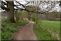
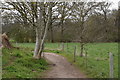
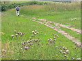
6

Greensand Way at Ivy Cottage
Narrow section of the long distance way, hemmed in by tall bracken and cow parsley at midsummer. The going is still firm and good as rainfall has been very light for 3 months.
http://www.ldwa.org.uk/ldp/members/show_path.php?path_name=Greensand+Way
Image: © Colin Smith
Taken: 10 Jul 2011
0.16 miles
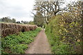
7
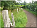
Greensand Way East of Dungate's Farm
Sandy surfaced long distance path parallelling the chalky North Downs to the north.
http://www.ldwa.org.uk/ldp/members/show_path.php?path_name=Greensand+Way
Image: © Colin Smith
Taken: 10 Jul 2011
0.17 miles
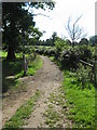
10
Greensand Way Near Dungate's Farm
On the Long Distance Way which runs from Haslemere to Hamstreet (Ashford). The path parallels the chalky North Downs.
http://www.ldwa.org.uk/ldp/members/show_path.php?path_name=Greensand+Way
Image: © Colin Smith
Taken: 10 Jul 2011
0.18 miles