IMAGES TAKEN NEAR TO
Dovers Green Road, REIGATE, RH2 8PN
Introduction
This page details the photographs taken nearby to Dovers Green Road, RH2 8PN by members of the Geograph project.
The Geograph project started in 2005 with the aim of publishing, organising and preserving representative images for every square kilometre of Great Britain, Ireland and the Isle of Man.

There are currently over 7.5m images from over14,400 individuals and you can help contribute to the project by visiting https://www.geograph.org.uk
Image Map
Images are licensed for reuse under creativecommons.org/licenses/by-sa/2.0
Notes
- Clicking on the map will re-center to the selected point.
- The higher the marker number, the further away the image location is from the centre of the postcode.
Image Listing (43 Images Found)
Images are licensed for reuse under creativecommons.org/licenses/by-sa/2.0
Image
Details
Distance
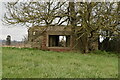
1
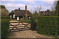
Former school, Dovers Green Road
Locally listed, dating from 1861. Reigate's only thatched building.
Image: © Ian Capper
Taken: 19 Apr 2009
0.00 miles
2
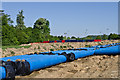
Water mains pipes
During 2013, Sutton and East Surrey Water have been laying a new 17km main connecting their pumping stations at Outwood and Buckland in a £14m project. The main contractors' site is on Dovers Green Road, as seen here. The lighting towers behind are for Reigate Grammar School's Hartswood playing fields.
Image: © Ian Capper
Taken: 27 May 2013
0.07 miles
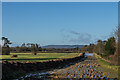
3
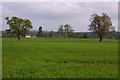
Towards Dovers Farm
Viewed from near Sidlow Bridge. Dovers Farm is grade II listed - see www.historicengland.org.uk/listing/the-list/list-entry/1029147. Note the pill box in the middle distance.
Image: © Ian Capper
Taken: 19 Apr 2009
0.09 miles
4
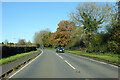
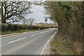
A217 Dovers Green Road
Towards Reigate.
Image: © Robin Webster
Taken: 18 Nov 2022
0.10 miles
6
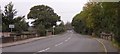
Sidlow Bridge
Sidlow Bridge in Sidlow, where the A217 crosses the River Mole.
Image: © Hywel Williams
Taken: 18 Oct 2005
0.15 miles
7
Route of new Water Main
During 2013, Sutton and East Surrey Water have been laying a new 17km main connecting their pumping stations at Outwood and Buckland in a £14m project. This is part of the route off Dovers Green Road. In the background is an area of flooding, following the wettest January on record in southern England.
In the far distance is Leith Hill and on the left are two pillboxes, examples of many that are situated along the route of the River Mole.
Image: © Ian Capper
Taken: 1 Feb 2014
0.16 miles
9
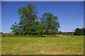
Pillboxes at Sidlow Bridge
This photo includes five pillboxes, presumably defending Sidlow Bridge as a potential crossing point of the River Mole.
They are:
- On the left
- Behind the second tree
- a pair in the distance to the left of the first electricity pole
- behind the second electricity pole
Image: © Ian Capper
Taken: 30 May 2009
0.17 miles
10
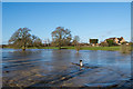
River Mole in flood
A flooded River Mole looking downstream from Sidlow Bridge, following a day and night of heavy rain, after the wettest January on record in southern England had left the ground saturated. In normal conditions the whole of this area would be dry land.
Image: © Ian Capper
Taken: 1 Feb 2014
0.17 miles