IMAGES TAKEN NEAR TO
Sandcross Lane, REIGATE, RH2 8LL
Introduction
This page details the photographs taken nearby to Sandcross Lane, RH2 8LL by members of the Geograph project.
The Geograph project started in 2005 with the aim of publishing, organising and preserving representative images for every square kilometre of Great Britain, Ireland and the Isle of Man.

There are currently over 7.5m images from over14,400 individuals and you can help contribute to the project by visiting https://www.geograph.org.uk
Image Map
Images are licensed for reuse under creativecommons.org/licenses/by-sa/2.0
Notes
- Clicking on the map will re-center to the selected point.
- The higher the marker number, the further away the image location is from the centre of the postcode.
Image Listing (70 Images Found)
Images are licensed for reuse under creativecommons.org/licenses/by-sa/2.0
Image
Details
Distance
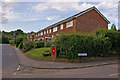
1
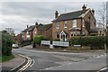
Sandcross Lane
Early 20th Century housing in Sandcross Lane, by its junction with Park Lane East.
Image: © Ian Capper
Taken: 10 Jan 2020
0.02 miles
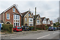
2
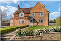
Whitehall Farmhouse
Former farmhouse on Sandcross Lane by its junction with New North Road. Dating from the 17th Century, it is grade II listed - see www.historicengland.org.uk/listing/the-list/list-entry/1029065.
Image: © Ian Capper
Taken: 3 Apr 2020
0.02 miles
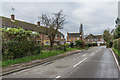
3
Reigate: Sandcross Lane
North Road goes off to the right.
Image: © Dr Neil Clifton
Taken: 23 Jul 2015
0.02 miles
4
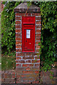
Edward VII post box, North Road/Sandcross Lane
On corner of North Road at its junction with Sandcross Lane (see Image).
Image: © Ian Capper
Taken: 25 Jul 2009
0.03 miles
5
Junction of North Road with Sandcross Lane
The houses here were built on the site of the former St Luke's Vicarage. For close up of Edwardian Post box, see Image
Image: © Ian Capper
Taken: 25 Jul 2009
0.03 miles
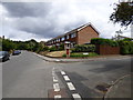
6
Park Lane East
1950s housing in Park Lane East. Those in the background, beyond the junction with Sandcross Lane, are early 20th Century.
Image: © Ian Capper
Taken: 10 Jan 2020
0.04 miles
7
89 - 97 Park Lane East
Early 20th Century housing in Park Lane East.
Image: © Ian Capper
Taken: 10 Jan 2020
0.04 miles
8
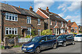
New North Road
Late 19th/early 20th Century houses in New North Road, an extension of the older North Road, as its name suggests.
Image: © Ian Capper
Taken: 3 Apr 2020
0.04 miles
9
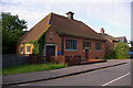
St Luke's Hall, South Park
Opened in 1908 as the church hall for St Luke's Church (see Image]). Now used by a Montessori nursery school. For a closeup of the foundation stone, see Image
Image: © Ian Capper
Taken: 10 Jun 2008
0.04 miles
10
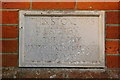
Foundation stone for St Luke's Hall
Image: © Ian Capper
Taken: 10 Jun 2008
0.04 miles