IMAGES TAKEN NEAR TO
Park Lane, REIGATE, RH2 8JZ
Introduction
This page details the photographs taken nearby to Park Lane, RH2 8JZ by members of the Geograph project.
The Geograph project started in 2005 with the aim of publishing, organising and preserving representative images for every square kilometre of Great Britain, Ireland and the Isle of Man.

There are currently over 7.5m images from over14,400 individuals and you can help contribute to the project by visiting https://www.geograph.org.uk
Image Map
Images are licensed for reuse under creativecommons.org/licenses/by-sa/2.0
Notes
- Clicking on the map will re-center to the selected point.
- The higher the marker number, the further away the image location is from the centre of the postcode.
Image Listing (57 Images Found)
Images are licensed for reuse under creativecommons.org/licenses/by-sa/2.0
Image
Details
Distance
2
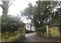
Reigate: Gateway and paddock off Park Lane
Image: © Dr Neil Clifton
Taken: 23 Jul 2015
0.07 miles
3
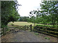
Driveway to Shepherd's Lodge
The rural appearance of this photo is misleading, given the proximity of the South Park district of Reigate to the south of here.
Image: © Ian Capper
Taken: 26 Apr 2009
0.07 miles
4
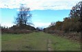
Ridge leading to W Top of Park Hill, Reigate Abbey Park, Surrey
Park Hill is a ridge stretching for 600m in an E-W direction. The hill occupies this grid square and the adjacent one Image The top of the ridge is quite flat, and gives good views in northerly and southerly directions. View taken looking W.
Image: © Pete Chapman
Taken: 3 Dec 2005
0.13 miles
5
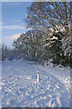
Greensand Way marker
A marker for the Greensand Way, here crossing Park Hill, almost fully encrusted in snow, with only the arrow showing. The snow cover is from a heavy fall a few days earlier.
Image: © Ian Capper
Taken: 9 Jan 2010
0.15 miles
6
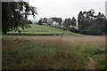
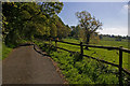
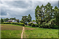
The Winding Path
The route of the path, to the distant cottages, is clearly visible.
Image: © Peter Trimming
Taken: 19 Sep 2018
0.15 miles
7
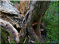
Downy Birch, Priory Park
See Image and Image for background. This close up of the trunk show at least three different types of fungus, the ultimate cause of its downfall (literally!)
Image: © Ian Capper
Taken: 4 May 2009
0.15 miles
8
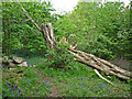
Downy Birch, Priory Park
This Downy Birch (Betula pubescens) was the largest in the country with a recorded trunk girth of 399cm at a point 0.9m above ground level. Unfortunately this honour proved too much for it, and in February 2009 it succumbed to fungal decay and collapsed, as seen here. Although some safety work has been carried out, the local council intends to leave the trunk standing, given its importance. In any case, it still has one branch with fresh leaves, so is not yet dead. See also Image for another view and Image for a close-up of the trunk.
Image: © Ian Capper
Taken: 4 May 2009
0.15 miles
9
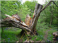
Downy Birch, Priory Park
This Downy Birch (Betula pubescens) was the largest in the country with a recorded trunk girth of 399cm at a point 0.9m above ground level. Unfortunately this honour proved too much for it, and in February 2009 it succumbed to fungal decay and collapsed, as seen here. Although some safety work has been carried out, the local council intends to leave the trunk standing, given its importance. In any case, it still has one branch with fresh leaves, so is not yet dead. See also Image for another view and Image for a close-up of the trunk.
Image: © Ian Capper
Taken: 4 May 2009
0.15 miles
10
Footpath to Ede's Fields
Footpath connecting Park Lane with the group of cottages known as Ede's Fields, seen in the background.
Image: © Ian Capper
Taken: 23 May 2020
0.16 miles