IMAGES TAKEN NEAR TO
Park Lane East, REIGATE, RH2 8HS
Introduction
This page details the photographs taken nearby to Park Lane East, RH2 8HS by members of the Geograph project.
The Geograph project started in 2005 with the aim of publishing, organising and preserving representative images for every square kilometre of Great Britain, Ireland and the Isle of Man.

There are currently over 7.5m images from over14,400 individuals and you can help contribute to the project by visiting https://www.geograph.org.uk
Image Map (Loading...)


Getting Data...Please wait
Leaflet Map data © OpenStreetMap
Images are licensed for reuse under creativecommons.org/licenses/by-sa/2.0
Notes
- Clicking on the map will re-center to the selected point.
- The higher the marker number, the further away the image location is from the centre of the postcode.
Image Listing (85 Images Found)
Images are licensed for reuse under creativecommons.org/licenses/by-sa/2.0
Image
Details
Distance
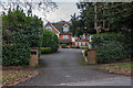
1

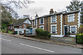
49 Park Lane East
House on Park Lane East, converted from a mission hall built around 1860. It was originally built as an adult school for men by the banker and art collector William Cleverley Alexander, whose family owned Woodhatch House on Cockshot Hill. It was initially used as a meeting room for the congregation of the future St Luke's Church, built in 1871 (see Image). In 1919, one of William Alexander's sons gave the hall to St Luke's Church in memory of his father, with the building being used as a Sunday School and for other meetings. It was eventually sold in 1969 to fund repairs to the main church building. Locally listed.
Image: © Ian Capper
Taken: 10 Jan 2020
0.00 miles
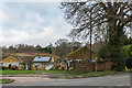
2
49 and 51 - 53 Park Lane East
51 - 53 Park Lane East (nearest) are a pair of semi-detached houses on Park Lane East, originally an orphanage - no, 51, the further section, has the inscription "The Old Orphanage" above its front window. Beyond is no 49, a former mission hall - see Image for full background.
Image: © Ian Capper
Taken: 10 Jan 2020
0.01 miles
3
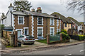
51 - 53 Park Lane East
Pair of semi-detached houses on Park Lane East, originally an orphanage - no, 51, the near section, has the inscription "The Old Orphanage" above its front window.
Image: © Ian Capper
Taken: 10 Jan 2020
0.01 miles
4
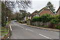
Park Lane East
Looking up Park Lane East from opposite Priory Road. The house on the right was built on the site of the Holmesdale Inn, which closed in the 1990s.
Image: © Ian Capper
Taken: 10 Jan 2020
0.01 miles
5
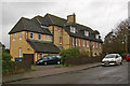
Margaret Laurie House
Built in 1880 as Mrs Kitto's Free Convalescent Home, which had been founded in 1872 in nearby Bletchingley, before moving here.
Mrs Kitto was the wife of The Revd J Fenwick Kitto, variously Vicar of St Matthias, Poplar (from 1867 to ?), Vicar of St Mary, Whitechapel (from ? to 1885(?)), Rector of St Dunstan, Stepney (from 1885 to 1886) and (from 1886 to 1903) Rector of St Martins-in-the-Fields in London. She established the convalescent home for the poor of East London, presumably prompted by her time living there.
The Home later became an annexe to the London Hospital, when it was known as Croft Home.
It now serves as an Inpatient Rehabilitation Unit, offering short term residential care and support for people in East Surrey and Elmbridge & Mid Surrey who have severe and enduring mental illness, to help them learn and regain lost life skills as part of their recovery journey.
Image: © Ian Capper
Taken: 29 Nov 2009
0.03 miles
6
Priory Oaks
Apartment block at 54 Park Lane East, completed in 2007.
Image: © Ian Capper
Taken: 10 Jan 2020
0.04 miles
7
68 - 76 Park Lane East
Some of a group of 1950s bungalows surrounding a green on the north side of Park Lane East, built on part of the grounds of the former Park House. In the background is Park Hill.
Image: © Ian Capper
Taken: 10 Jan 2020
0.04 miles
8
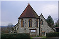
St Luke's Church
Built in around 1870 to serve the South Park area of Reigate. See http://www.southwark.anglican.org/parishes/219j1 for more details of the building. In the far distance can be seen Leith Hill, the highest point in south east England, over 10 miles away (see Image).
Image: © Ian Capper
Taken: 5 Jan 2008
0.05 miles
9
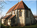
St Luke's church - East end
The apsidal east end and the south aisle of St Luke's parish church, Reigate - see also Image The 19th century building is built in the very soft local limestone, which requires frequent attention.
Image: © Stephen Craven
Taken: 27 Jan 2009
0.05 miles
10
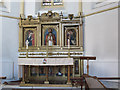
Altar and reredos in St Luke's church
The elaborate high altar and reredos of this church Image, along with the romanesque apse in which they are situated, date from a time when the parish's tradition was more "high church" than it is now.
Image: © Stephen Craven
Taken: 27 Jan 2009
0.05 miles