IMAGES TAKEN NEAR TO
Sandcross Lane, REIGATE, RH2 8HG
Introduction
This page details the photographs taken nearby to Sandcross Lane, RH2 8HG by members of the Geograph project.
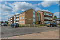
The Geograph project started in 2005 with the aim of publishing, organising and preserving representative images for every square kilometre of Great Britain, Ireland and the Isle of Man.

There are currently over 7.5m images from over14,400 individuals and you can help contribute to the project by visiting https://www.geograph.org.uk
Image Map
Images are licensed for reuse under creativecommons.org/licenses/by-sa/2.0
Notes
- Clicking on the map will re-center to the selected point.
- The higher the marker number, the further away the image location is from the centre of the postcode.
Image Listing (66 Images Found)
Images are licensed for reuse under creativecommons.org/licenses/by-sa/2.0
Image
Details
Distance
1
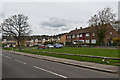
Sandcross Lane
A block of former council houses alongside some modern replacements.
Image: © Ian Capper
Taken: 28 Apr 2013
0.02 miles
2

Sandcross Lane
Modern replacement of former council housing.
Image: © Ian Capper
Taken: 28 Apr 2013
0.04 miles
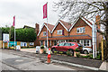
3
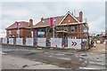
Earl's Grove
Development of 23 houses in Sandcross Lane, being built on the site of the former Reigate Garden Centre - see Image
Image: © Ian Capper
Taken: 10 Jan 2020
0.04 miles
4
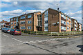
Ross House and Leith House
c1960s apartment blocks in Stockton Road in South Park by its junction with Apley Road, replacing previous c1020s housing.
Image: © Ian Capper
Taken: 3 Apr 2020
0.04 miles
5
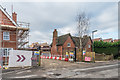
Earl's Grove
Entrance to Earl's Grove, a development of 23 houses in Sandcross Lane, being built on the site of the former Reigate Garden Centre - see Image The houses on the left, 145 - 147 Sandcross Lane, are a pair of Victorian semi-detached houses being retained within the development.
Image: © Ian Capper
Taken: 10 Jan 2020
0.05 miles
6
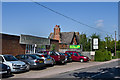
Reigate Garden Centre
Large independent garden centre in Sandcross Lane, established in 1983.
Image: © Ian Capper
Taken: 27 May 2013
0.05 miles
7
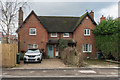
145 - 147 Sandcross Lane
Pair of Victorian semi-detached houses on Sandcross Lane.
Image: © Ian Capper
Taken: 10 Jan 2020
0.05 miles
8
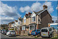
Stockton Road
Early 20th Century housing in the first section of Stockton Road to be developed.
Image: © Ian Capper
Taken: 3 Apr 2020
0.05 miles
9
Earl's Grove
Development of 23 houses in Sandcross Lane, being built on the site of the former Reigate Garden Centre - see Image
Image: © Ian Capper
Taken: 10 Jan 2020
0.06 miles
10
Munro House
c1960s apartment block in Stockton Road in South Park by its junction with Lyndhurst Road, replacing previous c1020s housing.
Image: © Ian Capper
Taken: 3 Apr 2020
0.06 miles