IMAGES TAKEN NEAR TO
Lonesome Lane, REIGATE, RH2 7QT
Introduction
This page details the photographs taken nearby to Lonesome Lane, RH2 7QT by members of the Geograph project.
The Geograph project started in 2005 with the aim of publishing, organising and preserving representative images for every square kilometre of Great Britain, Ireland and the Isle of Man.

There are currently over 7.5m images from over14,400 individuals and you can help contribute to the project by visiting https://www.geograph.org.uk
Image Map
Images are licensed for reuse under creativecommons.org/licenses/by-sa/2.0
Notes
- Clicking on the map will re-center to the selected point.
- The higher the marker number, the further away the image location is from the centre of the postcode.
Image Listing (10 Images Found)
Images are licensed for reuse under creativecommons.org/licenses/by-sa/2.0
Image
Details
Distance
3
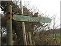
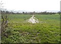
Public Footpath off Lonesome Lane
The writing on this sign reads "Public Footpath to Sidlow" and the path runs through open fields beyond the gate towards Sidlow Bridge.
Image: © Hywel Williams
Taken: 18 Oct 2005
0.06 miles
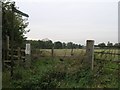
5
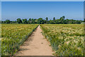
Footpath
Footpath 63 running across a barley field west of Lonesome Lane.
Image: © Ian Capper
Taken: 16 Jun 2021
0.08 miles
6
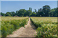
Footpath
Footpath 63 running across a barley field west of Lonesome Lane (in the background).
Image: © Ian Capper
Taken: 16 Jun 2021
0.09 miles
7
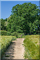
Footpath
Footpath 63 running across a barley field west of Lonesome Lane.
Image: © Ian Capper
Taken: 16 Jun 2021
0.18 miles
8
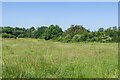
New Pond Farm
One of a network of grassland fields alongside Earlswood Brook and Felland Copse, owned by Reigate and Banstead Borough Council. The area was farmed until the mid 20th Century but is now open meadowland with mown paths for recreational use and is designated an SNCI.
Image: © Ian Capper
Taken: 16 Jun 2021
0.22 miles
9
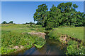
Earlswood Brook
The remains of a footbridge over Earlswood Brook, a small tributary of the River Mole. Old maps show the footpath that now runs on the east bank of the stream south of this point originally have run along the west bank, hence the bridge.
Image: © Ian Capper
Taken: 16 Jun 2021
0.23 miles