IMAGES TAKEN NEAR TO
Blackthorn Road, REIGATE, RH2 7NB
Introduction
This page details the photographs taken nearby to Blackthorn Road, RH2 7NB by members of the Geograph project.
The Geograph project started in 2005 with the aim of publishing, organising and preserving representative images for every square kilometre of Great Britain, Ireland and the Isle of Man.

There are currently over 7.5m images from over14,400 individuals and you can help contribute to the project by visiting https://www.geograph.org.uk
Image Map
Images are licensed for reuse under creativecommons.org/licenses/by-sa/2.0
Notes
- Clicking on the map will re-center to the selected point.
- The higher the marker number, the further away the image location is from the centre of the postcode.
Image Listing (40 Images Found)
Images are licensed for reuse under creativecommons.org/licenses/by-sa/2.0
Image
Details
Distance
1
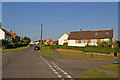
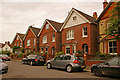
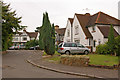
Blackthorn Road
This area of Reigate, between Woodhatch and Meadvale, was largely developed in the 1950s, with roads named after trees. This is Blackthorn Road, with Juniper Road off to the right.
Image: © Ian Capper
Taken: 23 Jun 2010
0.04 miles
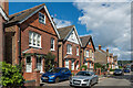
2
Hornbeam Road
This area of Reigate, between Woodhatch and Meadvale, was largely developed in the 1950s, with roads named after trees. This is Hornbeam Road, with Sycamore Walk off to the right.
Image: © Ian Capper
Taken: 23 Jun 2010
0.11 miles
3
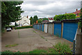
Garages at end of Rowan Close
Viewed from the end of the footpath from Arbutus Road.
Image: © Robin Webster
Taken: 14 Jul 2010
0.12 miles
4
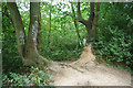
Woodland north of end of Willow Road
A scrap of woodland bounded by housing.
Image: © Robin Webster
Taken: 14 Jul 2010
0.15 miles
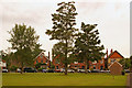
5
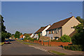
Furzefield Crescent
Houses in this crescent connecting Cornfield Road and Springcopse Road. For a 1910 photo of the same houses (but looking in the other direction) see http://www.francisfrith.com/reigate/photos/springcopse-road-1910_62761/.
Image: © Ian Capper
Taken: 26 Jul 2009
0.17 miles
6
Furzefield Crescent
Connecting Cornfield Road and Springcopse Road, and facing onto a semicircular green, seen here.
Image: © Ian Capper
Taken: 26 Jul 2009
0.17 miles
7
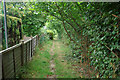
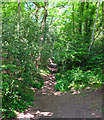
Footpath from Rowan Close to Arbutus Road
It runs behind back gardens on Blackthorn Road.
Image: © Robin Webster
Taken: 14 Jul 2010
0.17 miles
8
Furzefield Crescent
Late 19th/early 20th Century houses in Furzefield Crescent.
Image: © Ian Capper
Taken: 31 Aug 2020
0.18 miles
9
Hilltop Road
A group of 1930s semi-detached houses set round a circular shrubbery, off Smoke Lane.
Image: © Ian Capper
Taken: 26 Jul 2009
0.18 miles
10
Path between Arbutus Close and Cornfield road
Image: © Mark Chambers
Taken: 21 May 2019
0.19 miles