IMAGES TAKEN NEAR TO
St. Marys Road, REIGATE, RH2 7LP
Introduction
This page details the photographs taken nearby to St. Marys Road, RH2 7LP by members of the Geograph project.
The Geograph project started in 2005 with the aim of publishing, organising and preserving representative images for every square kilometre of Great Britain, Ireland and the Isle of Man.

There are currently over 7.5m images from over14,400 individuals and you can help contribute to the project by visiting https://www.geograph.org.uk
Image Map
Images are licensed for reuse under creativecommons.org/licenses/by-sa/2.0
Notes
- Clicking on the map will re-center to the selected point.
- The higher the marker number, the further away the image location is from the centre of the postcode.
Image Listing (46 Images Found)
Images are licensed for reuse under creativecommons.org/licenses/by-sa/2.0
Image
Details
Distance
1
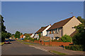
Hornbeam Road
This area of Reigate, between Woodhatch and Meadvale, was largely developed in the 1950s, with roads named after trees. This is Hornbeam Road, with Sycamore Walk off to the right.
Image: © Ian Capper
Taken: 23 Jun 2010
0.02 miles
2
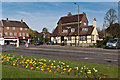
Trehaven
One of three shopping parades at the Woodhatch crossroads, this is the most modern. The building on right once housed Woodhatch Library.
Image: © Ian Capper
Taken: 26 May 2013
0.11 miles
3
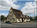
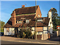
The Angel Public House, Woodhatch, Reigate
Grade II listed on 19 October 1951
Probably late C17 or early C18. This was called the White Horse Inn until 1814. Unusually-shaped timber-framed building consisting of a centre portion of 3 storeys, 1 window with gable end east and west. To the north and south are flanking portions of 2 storeys and 1 window each with pentice roofs up to the main building, but the pentices do not quite join the roof of the main portion but leave instead about one foot of upright wall between http://www.imagesofengland.org.uk/Details/Default.aspx?id=289445&mode=adv
Image: © Richard Rogerson
Taken: 2 Aug 2009
0.15 miles
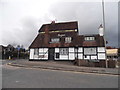
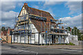
5
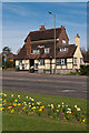
The Angel
Former pub dating from the late 17th or early 18th century which closed in February 2015. Until 1814 it was called the White Horse Inn. Seen here boarded up, although subsequent to this photo it is being converted to housing. Grade II listed - see www.historicengland.org.uk/listing/the-list/list-entry/1029079.
Image: © Ian Capper
Taken: 15 Sep 2018
0.15 miles
6
The Angel, Woodhatch
Grade II listed pub, dating from the late 17th or early 18th century. Until 1814 it was called the White Horse Inn. For listing particulars see www.historicengland.org.uk/listing/the-list/list-entry/1029079.
In the left background is part of Western Parade.
Image: © Ian Capper
Taken: 3 Apr 2011
0.15 miles
7
The Angel, Woodhatch
Grade II listed pub, dating from the late 17th or early 18th century. Until 1814 it was called the White Horse Inn. For listing particulars see www.historicengland.org.uk/listing/the-list/list-entry/1029079.
Image: © Ian Capper
Taken: 3 Apr 2011
0.15 miles
8
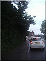
Cockshot Hill, Reigate
Waiting at the lights for the Woodhatch Road junction, the Angel pub can just be seen at the end.
Image: © David Howard
Taken: 16 Jul 2012
0.15 miles
9

The Angel, Woodhatch
Grade II listed pub, dating from the late 17th or early 18th century. Until 1814 it was called the White Horse Inn. For listing particulars see www.historicengland.org.uk/listing/the-list/list-entry/1029079.
Image: © Ian Capper
Taken: 10 Jun 2008
0.15 miles
10
The Angel
Former pub dating from the late 17th or early 18th century which closed in February 2015 and is now being converted to housing. Until 1814 it was called the White Horse Inn. Grade II listed - see www.historicengland.org.uk/listing/the-list/list-entry/1029079.
Image: © Ian Capper
Taken: 3 Apr 2020
0.15 miles