IMAGES TAKEN NEAR TO
Talbot Close, REIGATE, RH2 7HY
Introduction
This page details the photographs taken nearby to Talbot Close, RH2 7HY by members of the Geograph project.
The Geograph project started in 2005 with the aim of publishing, organising and preserving representative images for every square kilometre of Great Britain, Ireland and the Isle of Man.

There are currently over 7.5m images from over14,400 individuals and you can help contribute to the project by visiting https://www.geograph.org.uk
Image Map
Images are licensed for reuse under creativecommons.org/licenses/by-sa/2.0
Notes
- Clicking on the map will re-center to the selected point.
- The higher the marker number, the further away the image location is from the centre of the postcode.
Image Listing (196 Images Found)
Images are licensed for reuse under creativecommons.org/licenses/by-sa/2.0
Image
Details
Distance
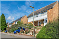
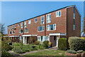
1
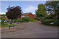
Harrison Close
Part of the 1960s or 70s Woodlands Estate (see Image). All the roads are named after vicars of St Mary's Church: in this photo are Harrison Close (named after John Harrison, vicar from 1847 to 1901) with Talbot Close off to the right (named after Richard Talbot, vicar from 1929 to 1947) and part of Lymden Gardens in the foreground (named after John Lymden, vicar from 1532 to 1536 and the last Prior of Reigate prior to the dissolution of Reigate Priory in the Reformation). The other roads on the estate are Sheldon Close (named after Frederick Sheldon, vicar from 1947 to 1957) and Cranston Close (named after Andrew Cranston, vicar from 1697 and 1708 and founder of the Cranston Library, the first public lending library in Britain - see Image).
Image: © Ian Capper
Taken: 25 Jul 2009
0.03 miles
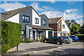
2
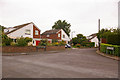
Orewell Gardens
A 1960s/1970s development off Smoke Lane.
Image: © Ian Capper
Taken: 26 Jul 2009
0.04 miles
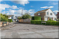
3
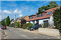
Smoke Lane
1960s houses on Smoke Lane (although the nearest one has since been fully refurbished). Historically Smoke Lane was the name given to the lane track, now footpath, to the south of here (see Image) - the name has since been transferred to this residential cul-de-sac.
Image: © Ian Capper
Taken: 31 Aug 2020
0.04 miles
4
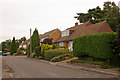
Smoke Lane
1960s housing on an extension of Smoke Lane (see Image).
Image: © Ian Capper
Taken: 26 Jul 2009
0.04 miles
5
Smoke Lane
1960s houses on Smoke Lane. Historically Smoke Lane was the name given to the lane track, now footpath, to the south of here (see Image) - the name has since been transferred to this residential cul-de-sac.
Image: © Ian Capper
Taken: 31 Aug 2020
0.04 miles
6
Orewell Gardens
1960s houses in a cul-de-sac off Smoke Lane (although the nearest one has since been fully refurbished).
Image: © Ian Capper
Taken: 31 Aug 2020
0.05 miles
7

Smoke Lane
1960s houses on Smoke Lane. Historically Smoke Lane was the name given to the lane track, now footpath, to the south of here (see Image) - the name has since been transferred to this residential cul-de-sac.
Image: © Ian Capper
Taken: 31 Aug 2020
0.05 miles
8
Orewell Gardens
1960s cul-de-sac off Smoke Lane (in the foreground).
Image: © Ian Capper
Taken: 31 Aug 2020
0.05 miles
9
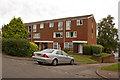
Cockshot Road
1960s maisonettes on a short extension to Cockshot Road.
Image: © Ian Capper
Taken: 26 Jul 2009
0.07 miles
10
45 - 61 Cockshot Road
c.1960s maisonettes in Cockshot Road.
Image: © Ian Capper
Taken: 19 Apr 2021
0.07 miles