IMAGES TAKEN NEAR TO
Crakell Road, REIGATE, RH2 7DT
Introduction
This page details the photographs taken nearby to Crakell Road, RH2 7DT by members of the Geograph project.
The Geograph project started in 2005 with the aim of publishing, organising and preserving representative images for every square kilometre of Great Britain, Ireland and the Isle of Man.

There are currently over 7.5m images from over14,400 individuals and you can help contribute to the project by visiting https://www.geograph.org.uk
Image Map
Images are licensed for reuse under creativecommons.org/licenses/by-sa/2.0
Notes
- Clicking on the map will re-center to the selected point.
- The higher the marker number, the further away the image location is from the centre of the postcode.
Image Listing (307 Images Found)
Images are licensed for reuse under creativecommons.org/licenses/by-sa/2.0
Image
Details
Distance
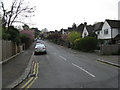
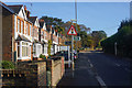
1
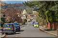
Crakell Road
Looking down Crackell Road towards Blackborough Road. Beyond the houses in the background can be seen some of the main building of Reigate Grammar School.
Image: © Ian Capper
Taken: 12 Apr 2021
0.02 miles
2
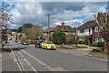
Crakell Road
Looking down Crackell Road towards Blackborough Road. On the skyline is the Reigate Hill TV transmitter.
Image: © Ian Capper
Taken: 12 Apr 2021
0.02 miles
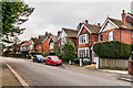
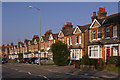
3
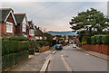
Crakell Road
Edwardian housing in a road linking Chart Lane with Blackborough Road (in the background).
Image: © Ian Capper
Taken: 29 Jan 2011
0.03 miles
4
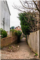
Footpath past Albion Road
Footpath connecting Chart Lane with Blackborough Road and on to St Mary's Churchyard, running past the end of Albion Road.
Image: © Ian Capper
Taken: 29 Jan 2011
0.03 miles
5
Reigate: Crakell Road
Looking south from Blackborough Road
Image: © Dr Neil Clifton
Taken: 18 Apr 2011
0.04 miles
6
Crakell Road
Edwardian housing in a road linking Chart Lane with Blackborough Road (in the background).
Image: © Ian Capper
Taken: 29 Jan 2011
0.04 miles
7
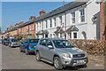
Albion Road
A cul-de-sac of terraced housing, mainly built in 1895.
Image: © Ian Capper
Taken: 19 Apr 2021
0.04 miles
8
Albion Road
A cul-de-sac of terraced housing, mainly built in 1895.
Image: © Ian Capper
Taken: 26 Jul 2009
0.05 miles
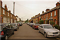
9
Terraced houses on Blackborough Road
A footpath crosses the road in the foreground. The trees in the background are on the site of the C of E primary school.
Image: © Bill Boaden
Taken: 11 Nov 2016
0.05 miles
10
Blackborough Road
Early 20th century housing backing onto St Mary's Churchyard.
Image: © Ian Capper
Taken: 21 Mar 2009
0.05 miles