IMAGES TAKEN NEAR TO
Castlefield Road, REIGATE, RH2 0SH
Introduction
This page details the photographs taken nearby to Castlefield Road, RH2 0SH by members of the Geograph project.
The Geograph project started in 2005 with the aim of publishing, organising and preserving representative images for every square kilometre of Great Britain, Ireland and the Isle of Man.

There are currently over 7.5m images from over14,400 individuals and you can help contribute to the project by visiting https://www.geograph.org.uk
Image Map
Images are licensed for reuse under creativecommons.org/licenses/by-sa/2.0
Notes
- Clicking on the map will re-center to the selected point.
- The higher the marker number, the further away the image location is from the centre of the postcode.
Image Listing (830 Images Found)
Images are licensed for reuse under creativecommons.org/licenses/by-sa/2.0
Image
Details
Distance
1
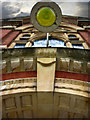
Porch Light
A vertical shot of the entranceway to the old town hall building.
Image: © Kurseong Carl
Taken: 16 Jul 2008
0.00 miles
2
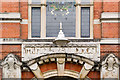
Doorway, Reigate Town Hall
Close up of one of the two original entrances to the building (see Image). This was the southern entrance (to the left of the gateway in the linked photo), giving access to what was the part that was the Town Hall from outset. For a photo of the other entrance, see Image For a view of the window above the door, from inside the building, see Image
Image: © Ian Capper
Taken: 11 Sep 2010
0.00 miles
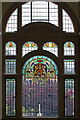
3
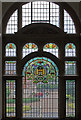
Window, Reigate Town Hall
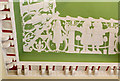
This is the window above the original Town Hall entrance to the building, viewed from inside the building. See Image for a wider view of the window, Image for an exterior view of the entrance and Image for a close up of the arms of the original Borough of Reigate depicted in the window.
Image: © Ian Capper
Taken: 11 Sep 2010
0.00 miles
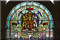
4
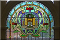
Original Borough of Reigate arms, Reigate Town Hall
Part of the window above the original Municipal Buildings entrance, depicting the arms of the original Borough of Reigate (see Image for a photo of the whole window). The castle represents Reigate Castle (see Image) and the shield above is that of William de Warenne who built the original Reigate Castle in the 11th century. The background to the arms is an oak tree. The motto "Never Wonne Ne Never Shall" refers to the victory of the men of Holmesdale over the Danes which supposedly took place in the late 9th century at a site between modern day Merstham and Redhill, known as Battlebridge. These arms were superseded by a new device in 1951 - see http://www.civicheraldry.co.uk/surrey_ob.html#reigate%20bc for a depiction and description of both (if this link does not take you straight to the section headed "Reigate Borough Council", you will need to scroll down to it).
Image: © Ian Capper
Taken: 11 Sep 2010
0.00 miles
5
Detail of ceiling, Old Council Chamber, Reigate Town Hall
A detail of the ornate plastered ceiling of the Old Council Chamber of Reigate Town Hall (see Image for a wider view of part of the room). The frieze depicts young girls representing various public virtues and activities. Note also the ornate cornice.
Image: © Ian Capper
Taken: 11 Sep 2010
0.00 miles
6
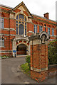
Reigate Town Hall
One of the entrances to Reigate Town Hall, the offices of Reigate and Banstead Borough Council in Castlefield Road, dating from 1901. The building was designed by the architects Hugh Macintosh and Reginald Newman.
For photo of the whole building, see Image
Grade II listed - for listing particulars see www.historicengland.org.uk/listing/the-list/list-entry/1260489.
Image: © Ian Capper
Taken: 5 Jul 2009
0.01 miles
7
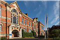
Reigate Town Hall
The offices of Reigate and Banstead Borough Council in Castlefield Road, dating from 1901. The building was designed by the architects Hugh Macintosh and Reginald Newman.
It was originally known as the Municipal Buildings, housing the Town Hall (which was in the nearest section of the building in this photo), the police station and court house (at the far end) and fire station (off the left of this photo - see Image). The police station is now in Reigate Road (see Image), having first moved to Cherchefelle (see Image) then, the courts are now in Hatchlands Road (see Image) and the fire station in Croydon Road (see Image), leaving the local council, now expanded from the original Borough of Reigate, as the sole occupant since 1974.
The building is grade II listed - see www.historicengland.org.uk/listing/the-list/list-entry/1260489.
Image: © Ian Capper
Taken: 3 Aug 2014
0.01 miles
8
Doorway, Reigate Town Hall
Close up of one of the two original entrances to the building (see Image). This was the northern entrance (beyond the flags in the linked photo), giving access to what was once the police station and court house. For a photo of the other entrance, see Image For a view of the window above the door, from inside the building, see Image
Image: © Ian Capper
Taken: 11 Sep 2010
0.01 miles
9
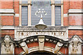
Window, Reigate Town Hall
This is the window above the original Court House and Police Station entrance to the building, viewed from inside the building. See Image for an exterior view of the entrance and Image for a close up of the royal coat of arms depicted in the window.
Image: © Ian Capper
Taken: 11 Sep 2010
0.01 miles
10
Royal Coat of Arms, Reigate Town Hall
Close up of the royal coat of arms in the window in Image
Image: © Ian Capper
Taken: 11 Sep 2010
0.01 miles