IMAGES TAKEN NEAR TO
Deerings Road, REIGATE, RH2 0PH
Introduction
This page details the photographs taken nearby to Deerings Road, RH2 0PH by members of the Geograph project.
The Geograph project started in 2005 with the aim of publishing, organising and preserving representative images for every square kilometre of Great Britain, Ireland and the Isle of Man.

There are currently over 7.5m images from over14,400 individuals and you can help contribute to the project by visiting https://www.geograph.org.uk
Image Map
Images are licensed for reuse under creativecommons.org/licenses/by-sa/2.0
Notes
- Clicking on the map will re-center to the selected point.
- The higher the marker number, the further away the image location is from the centre of the postcode.
Image Listing (318 Images Found)
Images are licensed for reuse under creativecommons.org/licenses/by-sa/2.0
Image
Details
Distance
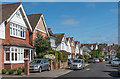
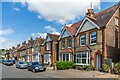
1
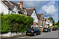
Deerings Road
A road developed from 1898 onwards in the former grounds of Great Doods. Great Doods itself was demolished in 1910.
Image: © Ian Capper
Taken: 15 Jun 2013
0.00 miles
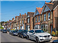
2
Deerings Road
A road developed from 1898 onwards in the former grounds of Great Doods. Great Doods itself was demolished in 1910.
Image: © Ian Capper
Taken: 25 Apr 2020
0.02 miles
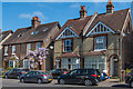
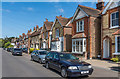
3
Eversfield Road
Edwardian houses built on the site of a 17th century mansion, Great Doods.
Image: © Ian Capper
Taken: 25 Apr 2020
0.03 miles
4
Eversfield Road
Edwardian houses built on the site of a 17th century mansion, Great Doods.
Image: © Ian Capper
Taken: 15 Jun 2013
0.03 miles
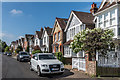
5
Eversfield Road
Edwardian houses built on the site of a 17th century mansion, Great Doods.
Image: © Ian Capper
Taken: 25 Apr 2020
0.04 miles
6
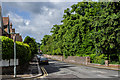
Croydon Road
Looking towards its junction with Church Street in the far distance.
The wall on the right mark the boundary of what were originally the grounds of Reigate Lodge, a large 18th century mansion. The house was demolished in the 1920s and the land used for what is now Reigate College (see Image) and housing, for example Rushworth Road (see Image). However the surrounding walls and shrubbery were retained, giving some privacy to the houses built immediately behind them, East Walk being along this section.
Image: © Ian Capper
Taken: 15 Jun 2013
0.04 miles
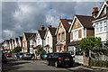
8
Deerings Road
A road developed from 1898 onwards in the former grounds of Great Doods. The nearest house has a date in its gable of 1903. Great Doods itself was demolished in 1910.
Image: © Ian Capper
Taken: 25 Apr 2020
0.04 miles
9
Deerings Road
A road developed from 1898 onwards in the former grounds of Great Doods. Great Doods itself was demolished in 1910.
Image: © Ian Capper
Taken: 5 Jul 2022
0.04 miles
10
Deerings Road
A road developed from 1898 onwards in the former grounds of Great Doods. Great Doods itself was demolished in 1910.
Image: © Ian Capper
Taken: 25 Apr 2020
0.04 miles