IMAGES TAKEN NEAR TO
Wilmots Close, REIGATE, RH2 0NP
Introduction
This page details the photographs taken nearby to Wilmots Close, RH2 0NP by members of the Geograph project.
The Geograph project started in 2005 with the aim of publishing, organising and preserving representative images for every square kilometre of Great Britain, Ireland and the Isle of Man.

There are currently over 7.5m images from over14,400 individuals and you can help contribute to the project by visiting https://www.geograph.org.uk
Image Map
Images are licensed for reuse under creativecommons.org/licenses/by-sa/2.0
Notes
- Clicking on the map will re-center to the selected point.
- The higher the marker number, the further away the image location is from the centre of the postcode.
Image Listing (130 Images Found)
Images are licensed for reuse under creativecommons.org/licenses/by-sa/2.0
Image
Details
Distance
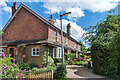
1
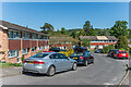
Wilmots Close
A 1960s cul-de-sac off Doods Road.
Image: © Ian Capper
Taken: 15 May 2020
0.02 miles
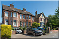
2
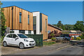
Wilmots Close
A 1960s cul-de-sac off Doods Road. The nearest house, no. 1, was originally a bungalow, significantly extended in 2019.
Image: © Ian Capper
Taken: 15 May 2020
0.02 miles
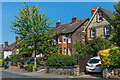
3
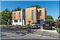
1 Wilmots Close
A 1960s bungalow, significantly extended in 2019.
Image: © Ian Capper
Taken: 15 May 2020
0.03 miles
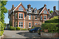
4
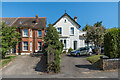
72 and 74 Doods Road
Large Victorian houses in Doods Road. No 72, on the left, is one of a pair of semi-detached houses (other than the roof, its partner, no. 70, is not visible in this photo). No 74, on the right, named Doods Brow, was for many years occupied by a school of that name until it moved to Nutfield to utilise the former village school there (see Image).
Image: © Ian Capper
Taken: 15 May 2020
0.05 miles
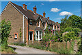
5
Doods Brow Cottages
Small terrace of cottages down a track off Doods Road, dating from around the turn of the 19th/20th Centuries. An early example of backland development, it would appear.
Image: © Ian Capper
Taken: 13 Jun 2020
0.05 miles
6
64 - 66 Doods Road
A pair of large semi-detached late Victorian houses in Doods Road. No 68, on the right is of a similar age.
Image: © Ian Capper
Taken: 15 May 2020
0.05 miles
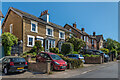
7
Doods Road
Late Victorian houses in Doods Road.
Image: © Ian Capper
Taken: 15 May 2020
0.05 miles
8
78 - 80 Doods Road
Large late Victorian pair of semi-detached houses in Doods Road.
Image: © Ian Capper
Taken: 15 May 2020
0.06 miles
9
Doods Road
Late Victorian houses in Doods Road.
Image: © Ian Capper
Taken: 15 May 2020
0.06 miles
10
Wray View Cottages
Small terrace of cottages down a track off Doods Road, dating from around the turn of the 19th/20th Centuries. An early example of backland development.
Image: © Ian Capper
Taken: 13 Jun 2020
0.06 miles