IMAGES TAKEN NEAR TO
The Cedars, REIGATE, RH2 0JS
Introduction
This page details the photographs taken nearby to The Cedars, RH2 0JS by members of the Geograph project.
The Geograph project started in 2005 with the aim of publishing, organising and preserving representative images for every square kilometre of Great Britain, Ireland and the Isle of Man.

There are currently over 7.5m images from over14,400 individuals and you can help contribute to the project by visiting https://www.geograph.org.uk
Image Map
Images are licensed for reuse under creativecommons.org/licenses/by-sa/2.0
Notes
- Clicking on the map will re-center to the selected point.
- The higher the marker number, the further away the image location is from the centre of the postcode.
Image Listing (108 Images Found)
Images are licensed for reuse under creativecommons.org/licenses/by-sa/2.0
Image
Details
Distance
1
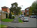
Fir Tree Walk
Part of an estate managed by Mount Green Housing Association.
Image: © Ian Capper
Taken: 4 May 2009
0.03 miles
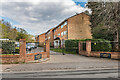
2
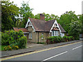
East Lodge, Doods Park Road
Lodge at the junction of Doods Park Road and Wray Common Road, first shown on the 1896 1:2,500 map, presumably built to serve a large late Victorian house further along Doods Park Road named Rookwood (now demolished).
Image: © Ian Capper
Taken: 4 May 2009
0.05 miles
3
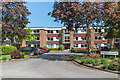
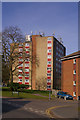
Howard Court
c.1970s apartment block on Doods Park Road built on the site of a large late 19th/early 20th Century house named Rannoch Lodge.
Image: © Ian Capper
Taken: 15 May 2020
0.07 miles
4
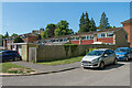
The Cedars
Part of a small c.1960s mixed estate between Reigate Road and Wray Common Road, built on the site of four large late Victorian houses, Firlands and Grassmead on the former, Lowood (originally Low Wood) and West House on the latter.
Image: © Ian Capper
Taken: 15 May 2020
0.07 miles
5
Fir Tree Walk
Block of flats operated by Mount Green Housing Association.
Image: © Ian Capper
Taken: 15 Mar 2009
0.08 miles
6
Clairville Court
c.1960s/70s apartments off Wray Common Road built on the site of a large late Victorian house named Clairville.
Image: © Ian Capper
Taken: 12 Apr 2021
0.09 miles
7
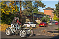
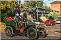
London to Brighton Veteran Car Run 2017 on Reigate Road
1902 Renault two-seater registration no BS 8336 (start no 134) passing Fir Tree Walk, opposite Reigate Police Station.
Image: © Ian Capper
Taken: 5 Nov 2017
0.09 miles
8
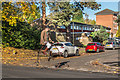
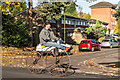
London to Brighton Veteran Car Run 2017 on Reigate Road
A cyclist on a Penny Farthing joins in the fun, seen here passing Fir Tree Walk, opposite Reigate Police Station.
Image: © Ian Capper
Taken: 5 Nov 2017
0.09 miles
9
London to Brighton Veteran Car Run 2017 on Reigate Road
1903 Renault tonneau registration no 11 ALW (start no 244) passing Fir Tree Walk, opposite Reigate Police Station.
Image: © Ian Capper
Taken: 5 Nov 2017
0.09 miles
10
London to Brighton Veteran Car Run 2017 on Reigate Road
A cyclist on a Boneshaker joins in the fun, seen here passing Fir Tree Walk, opposite Reigate Police Station.
Image: © Ian Capper
Taken: 5 Nov 2017
0.09 miles