IMAGES TAKEN NEAR TO
Wray Lane, REIGATE, RH2 0HX
Introduction
This page details the photographs taken nearby to Wray Lane, RH2 0HX by members of the Geograph project.
The Geograph project started in 2005 with the aim of publishing, organising and preserving representative images for every square kilometre of Great Britain, Ireland and the Isle of Man.

There are currently over 7.5m images from over14,400 individuals and you can help contribute to the project by visiting https://www.geograph.org.uk
Image Map (Loading...)


Getting Data...Please wait
Leaflet Map data © OpenStreetMap
Images are licensed for reuse under creativecommons.org/licenses/by-sa/2.0
Notes
- Clicking on the map will re-center to the selected point.
- The higher the marker number, the further away the image location is from the centre of the postcode.
Image Listing (91 Images Found)
Images are licensed for reuse under creativecommons.org/licenses/by-sa/2.0
Image
Details
Distance
1
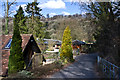
Wray Lane
Houses on a short spur off Wray Lane, with Reigate Hill in the background.
Image: © Ian Capper
Taken: 2 Apr 2013
0.02 miles
2
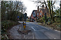
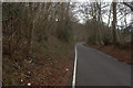
Wray Lane
Wray Lane is used as a route from Redhill and Wray Common to the top of Reigate Hill, where Junction 8 of the M25 is situated. Originally two way, it was made one way only at the top end in the late 1980s or so. Here is the start of the one way section, with a speed ramp to reduce speeding. On the left is the end of a short stretch of contraflow cycle lane, linking from a bridleway from Gatton Park.
Image: © Ian Capper
Taken: 2 Apr 2013
0.05 miles
3
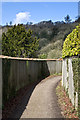
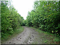
Bridleway below Reigate Hill
A bridleway connecting Reigate Hill (the road up Reigate Hill) and Wray Lane. In the background among the trees can be seen the Bridge House Hotel.
Image: © Ian Capper
Taken: 2 Apr 2013
0.05 miles
6
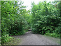
Track in Nut Wood
National Trust property.
Image: © Robin Webster
Taken: 26 Aug 2010
0.09 miles
7
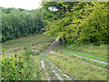
Path in Nut Wood
Public access woodland.
Image: © Robin Webster
Taken: 26 Aug 2010
0.10 miles
9
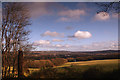
Merstham from Gatton
A view of Merstham in the distance from Gatton Park
Image: © Kurseong Carl
Taken: 16 Dec 2012
0.11 miles
10
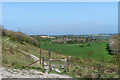
Wingate Hill
A path across Wingate Hill in the National Trust owned Gatton Park. In the background is the Royal Alexandra and Albert School, whose buildings include Gatton Hall.
Image: © Ian Capper
Taken: 13 Apr 2020
0.12 miles