IMAGES TAKEN NEAR TO
Laglands Close, REIGATE, RH2 0HW
Introduction
This page details the photographs taken nearby to Laglands Close, RH2 0HW by members of the Geograph project.
The Geograph project started in 2005 with the aim of publishing, organising and preserving representative images for every square kilometre of Great Britain, Ireland and the Isle of Man.

There are currently over 7.5m images from over14,400 individuals and you can help contribute to the project by visiting https://www.geograph.org.uk
Image Map
Images are licensed for reuse under creativecommons.org/licenses/by-sa/2.0
Notes
- Clicking on the map will re-center to the selected point.
- The higher the marker number, the further away the image location is from the centre of the postcode.
Image Listing (42 Images Found)
Images are licensed for reuse under creativecommons.org/licenses/by-sa/2.0
Image
Details
Distance
1
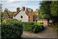
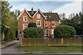
61 - 65 Raglan Road
Mid 19th Century group of buildings on Raglan Road by its junction with Gatton Road.
Image: © Ian Capper
Taken: 7 Apr 2020
0.04 miles
2
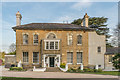
Wray Park Hall
A large mid 19th century house in Alma Road, now a care home. Grade II listed - see www.historicengland.org.uk/listing/the-list/list-entry/1180277.
Image: © Ian Capper
Taken: 7 Apr 2020
0.14 miles
3
Wray Park Hall
A large mid 19th century house in Alma Road, now a care home. Grade II listed - see www.historicengland.org.uk/listing/the-list/list-entry/1180277.
Image: © Ian Capper
Taken: 20 Apr 2008
0.14 miles
4
Wray Park Hall
A large mid 19th century house in Alma Road, now a care home. Grade II listed - see www.historicengland.org.uk/listing/the-list/list-entry/1180277. The gates are separately grade II listed - see www.historicengland.org.uk/listing/the-list/list-entry/1029171.
Image: © Ian Capper
Taken: 20 Apr 2008
0.14 miles
5
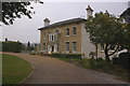
Caverswall Court
Large 19th Century house in Alders Road, marked simply as Caverswall on older maps, now subdivided into flats.
Image: © Ian Capper
Taken: 7 Apr 2020
0.15 miles
6
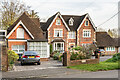
47 and 49 Alma Road
Houses on Alma Road. No 47 (The Copse), on the right, is mid 19th Century and locally listed. No 49 is later, a building first being shown on the site on the 1914 1,2500 map, possibly as a garage to the main house, which was presumably later converted.
Image: © Ian Capper
Taken: 7 Apr 2020
0.15 miles
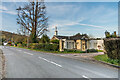
7
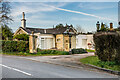
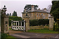
Wray Park Lodge
Lodge to Wray Park Hall in Alma Road (see Image). Built in the mid 19th Century it is grade II listed - see www.historicengland.org.uk/listing/the-list/list-entry/1029170 - with the gate piers being separately grade II listed - see www.historicengland.org.uk/listing/the-list/list-entry/1029171.
Image: © Ian Capper
Taken: 7 Apr 2020
0.15 miles
8

Greystones Drive
Mid 1960s - 1970s cul de sac of Gatton Road on the site of a Victorian house called Highfield, renamed Greystones by the 1930s.
Image: © Ian Capper
Taken: 15 Jun 2013
0.16 miles
9
Fairford Close
1980s cul de sac off Brightlands Road.
Image: © Ian Capper
Taken: 18 Mar 2012
0.16 miles
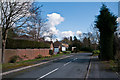
10
Wray Park Lodge
Lodge to Wray Park Hall in Alma Road (see Image). Built in the mid 19th Century it is grade II listed - see www.historicengland.org.uk/listing/the-list/list-entry/1029170 - with the gate piers being separately grade II listed - see www.historicengland.org.uk/listing/the-list/list-entry/1029171.
In the background is Raglan Road - the postbox visible is the "anonymous" postbox in Image
Image: © Ian Capper
Taken: 7 Apr 2020
0.16 miles