IMAGES TAKEN NEAR TO
Alders Road, REIGATE, RH2 0EA
Introduction
This page details the photographs taken nearby to Alders Road, RH2 0EA by members of the Geograph project.
The Geograph project started in 2005 with the aim of publishing, organising and preserving representative images for every square kilometre of Great Britain, Ireland and the Isle of Man.

There are currently over 7.5m images from over14,400 individuals and you can help contribute to the project by visiting https://www.geograph.org.uk
Image Map
Images are licensed for reuse under creativecommons.org/licenses/by-sa/2.0
Notes
- Clicking on the map will re-center to the selected point.
- The higher the marker number, the further away the image location is from the centre of the postcode.
Image Listing (52 Images Found)
Images are licensed for reuse under creativecommons.org/licenses/by-sa/2.0
Image
Details
Distance
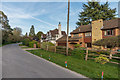
1
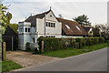
12 Alders Road
Former lodge (with a later extension on the right) to a large house called Ivanhoe, now demolished and the land developed as Yardley Close in the 1970s. The lodge is by Read & MacDonald and was built in 1892. Locally listed. For a photo of both the lodge and Ivanhoe, seen from the rear, see https://www.oldreigate.com/index.php?goto=picture_67&prevurl=aldersroad.
Image: © Ian Capper
Taken: 7 Apr 2020
0.04 miles
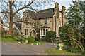
2
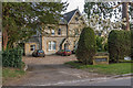
Alders House
Large mid 19th Century house in Alders Road, subdivided into 6 flats in the 1980s. Locally listed.
Image: © Ian Capper
Taken: 7 Apr 2020
0.05 miles
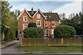
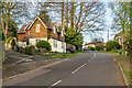
3
10 Alders Road
An early Arts and Crafts house built around 1894. Locally listed.
Image: © Ian Capper
Taken: 7 Apr 2020
0.05 miles
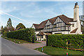
4
Caverswall Court
Large 19th Century house in Alders Road, marked simply as Caverswall on older maps, now subdivided into flats.
Image: © Ian Capper
Taken: 7 Apr 2020
0.06 miles
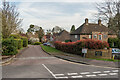
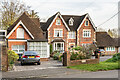
5
8 and 10 Alders Road
Houses in Alders Road. No 10, in the background, was built around 1894 and is locally listed. For closer view see Image
Image: © Ian Capper
Taken: 7 Apr 2020
0.07 miles
6
43 Alma Road
Mid 19th Century house on Alma Road. Locally listed.
Image: © Ian Capper
Taken: 7 Apr 2020
0.09 miles
7
Alma Road
Looking up Alma Road. In the distance is Wray Park Hall (see Image). On the left is no 52, built in the mid 19th Century as the lodge to The Briars.
Image: © Ian Capper
Taken: 7 Apr 2020
0.10 miles
8
Sheridan Drive
1990s development on land behind nos 31 - 35 Alma Road.
Image: © Ian Capper
Taken: 7 Apr 2020
0.11 miles
9
47 and 49 Alma Road
Houses on Alma Road. No 47 (The Copse), on the right, is mid 19th Century and locally listed. No 49 is later, a building first being shown on the site on the 1914 1,2500 map, possibly as a garage to the main house, which was presumably later converted.
Image: © Ian Capper
Taken: 7 Apr 2020
0.11 miles
10
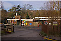
Brooklands School
A Surrey County Council community day special school for children with severe or profound and multiple learning difficulties between the ages of 2 and 11 years.
Image: © Ian Capper
Taken: 24 Jan 2009
0.13 miles