IMAGES TAKEN NEAR TO
Oak Road, REIGATE, RH2 0BP
Introduction
This page details the photographs taken nearby to Oak Road, RH2 0BP by members of the Geograph project.
The Geograph project started in 2005 with the aim of publishing, organising and preserving representative images for every square kilometre of Great Britain, Ireland and the Isle of Man.

There are currently over 7.5m images from over14,400 individuals and you can help contribute to the project by visiting https://www.geograph.org.uk
Image Map
Images are licensed for reuse under creativecommons.org/licenses/by-sa/2.0
Notes
- Clicking on the map will re-center to the selected point.
- The higher the marker number, the further away the image location is from the centre of the postcode.
Image Listing (176 Images Found)
Images are licensed for reuse under creativecommons.org/licenses/by-sa/2.0
Image
Details
Distance
1
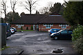
Ellen Terry Day Unit
A day centre for adults with a learning disability and challenging behaviour, situated in Oak Road. It is operated by Surrey and Borders Partnership NHS Foundation Trust.
It is named after Ellen Terry, the actress who became almost blind in 1915 and who was president of the Blind League. The League had a home for blind mentally handicapped children nearby in Wray Park Road, named Sandfield House and founded in 1925. Following absorption in the NHS in 1948, it underwent a number of changes of roles over the years, before closing in 1986. The present day unit was built to the south of the original site.
Image: © Ian Capper
Taken: 26 Jan 2013
0.03 miles
2
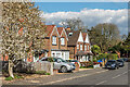
Warren Road
Early 20th Century housing in Warren Road.
Image: © Ian Capper
Taken: 12 Apr 2021
0.04 miles
3
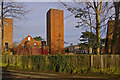
Reigate Fire Station training towers
Training towers at Reigate Fire Station, with the offices of the Surrey Fire & Rescue Service in the background (see Image).
Image: © Ian Capper
Taken: 24 Jan 2009
0.04 miles
4
42 - 44 Warren Road
Victorian pair of semi-detached houses, shown on the 1872 1:500 plan.
Image: © Ian Capper
Taken: 28 Jun 2020
0.06 miles
5
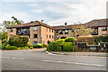
Wraymead Place, Wray Park Road
Development of 39 retirement flats on Wray Park Road, completed in 1988.
Image: © Ian Capper
Taken: 7 Apr 2020
0.06 miles
6
Warren Court
Victorian house, shown on the 1872 1:500 plan. Originally a pair of semi-detached houses, 38 - 40 Warren Road, now subdivided into flats.
Image: © Ian Capper
Taken: 28 Jun 2020
0.06 miles
7
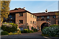
Wraymead Place
A sheltered housing development on Wray Park Road, completed in 1988 and built on the site of the original Ellen Terry Home.
Image: © Ian Capper
Taken: 27 May 2012
0.07 miles
8
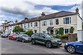
20 - 36 Warren Road
Victorian terrace, shown on the 1872 1:500 plan.
Image: © Ian Capper
Taken: 28 Jun 2020
0.08 miles
9
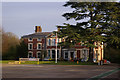
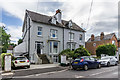
The Dingle
This Victorian building, now much added to, currently contains the offices of the Surrey Fire & Rescue Service. It was built by Joseph Crosfield in the 1850s(?), the Crosfields being a prominent Reigate family for many years (see Image - James Backhouse Crosfield was Joseph Crosfield's eldest son). The directory on the back of the 1895 Godfrey Edition map of Reigate lists a William G Druce as living there.
Image: © Ian Capper
Taken: 24 Jan 2009
0.09 miles
10
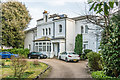
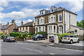
Kilmarnock, 30 Wray Park Road
Large mid 19th Century house, now divided into 6 flats. Locally listed.
Image: © Ian Capper
Taken: 7 Apr 2020
0.09 miles