IMAGES TAKEN NEAR TO
Warren Road, REIGATE, RH2 0BN
Introduction
This page details the photographs taken nearby to Warren Road, RH2 0BN by members of the Geograph project.
The Geograph project started in 2005 with the aim of publishing, organising and preserving representative images for every square kilometre of Great Britain, Ireland and the Isle of Man.

There are currently over 7.5m images from over14,400 individuals and you can help contribute to the project by visiting https://www.geograph.org.uk
Image Map
Images are licensed for reuse under creativecommons.org/licenses/by-sa/2.0
Notes
- Clicking on the map will re-center to the selected point.
- The higher the marker number, the further away the image location is from the centre of the postcode.
Image Listing (292 Images Found)
Images are licensed for reuse under creativecommons.org/licenses/by-sa/2.0
Image
Details
Distance
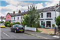
1
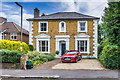
6 Warren Road
Victorian villa named Orchard House on the 1872 1:500 plan.
Image: © Ian Capper
Taken: 28 Jun 2020
0.00 miles
2
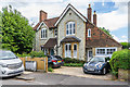
4 Warren Road
Late Victorian house built out of Reigate stone.
Image: © Ian Capper
Taken: 28 Jun 2020
0.01 miles
3
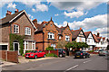
Warren Road
Houses in Warren Road - the unusual central pair dates from the turn of the 19th/20th centuries.
Image: © Ian Capper
Taken: 12 May 2012
0.02 miles
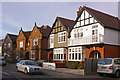
4
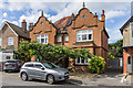
53 - 55 Warren Road
Pair of semi-detached houses with ornate gables, first shown on the 1914 1:2,500 map. The 4 November 1930 edition of the London Gazette names the nearer of the two, no 55, as Glen Villa.
Image: © Ian Capper
Taken: 28 Jun 2020
0.02 miles
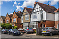
5
Warren Road
A couple of contrasting semi-detached houses, which, judging from their absence from the 1895 Godfrey Edition of Reigate, date from the late 1890s/early 20th century.
Image: © Ian Capper
Taken: 24 Jan 2009
0.02 miles
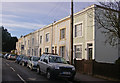
6
25 - 43 Warren Road
Victorian terrace, first shown on the 1872 1:500 map.
Image: © Ian Capper
Taken: 28 Jun 2020
0.02 miles
7
53 - 55 and 57 - 59 Warren Road
Two pairs of semi-detached houses, first shown on the 1914 1:2,500 map. For close up of nos 53 - 55 see Image
Image: © Ian Capper
Taken: 28 Jun 2020
0.02 miles
8
8 - 16 Warren Road
Victorian terrace, named Laurel Terrace on the 1872 1:500 plan.
Image: © Ian Capper
Taken: 28 Jun 2020
0.03 miles
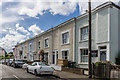
9
Warren Road
This unusual terrace of houses is the only development on the northern side of Warren Road shown in the 1895 Godfrey Edition map of Reigate.
Image: © Ian Capper
Taken: 24 Jan 2009
0.03 miles
10
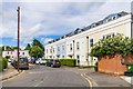
Gooding House
2012 development in Warren Road on the site of a former dairy depot. Compare the Victorian terrace in the background (see Image for closer view), which clearly influenced the design of Gooding House.
Image: © Ian Capper
Taken: 28 Jun 2020
0.03 miles