IMAGES TAKEN NEAR TO
Doods Park Road, REIGATE, RH2 0AQ
Introduction
This page details the photographs taken nearby to Doods Park Road, RH2 0AQ by members of the Geograph project.
The Geograph project started in 2005 with the aim of publishing, organising and preserving representative images for every square kilometre of Great Britain, Ireland and the Isle of Man.

There are currently over 7.5m images from over14,400 individuals and you can help contribute to the project by visiting https://www.geograph.org.uk
Image Map
Images are licensed for reuse under creativecommons.org/licenses/by-sa/2.0
Notes
- Clicking on the map will re-center to the selected point.
- The higher the marker number, the further away the image location is from the centre of the postcode.
Image Listing (111 Images Found)
Images are licensed for reuse under creativecommons.org/licenses/by-sa/2.0
Image
Details
Distance
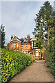
1
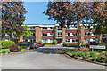
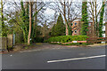
Howard Court
c.1970s apartment block on Doods Park Road built on the site of a large late 19th/early 20th Century house named Rannoch Lodge.
Image: © Ian Capper
Taken: 15 May 2020
0.01 miles
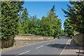
2
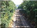
View off Railway Bridge in Reigate
This bridge is in roughly the centre of the square. The first bridge visible is within but the second bridge in the distance marks the edge of the square.
Image: © Hywel Williams
Taken: 21 Jul 2005
0.02 miles
3
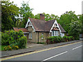
East Lodge, Doods Park Road
Lodge at the junction of Doods Park Road and Wray Common Road, first shown on the 1896 1:2,500 map, presumably built to serve a large late Victorian house further along Doods Park Road named Rookwood (now demolished).
Image: © Ian Capper
Taken: 4 May 2009
0.03 miles
4
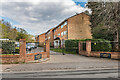
Clairville Court
c.1960s/70s apartments off Wray Common Road built on the site of a large late Victorian house named Clairville.
Image: © Ian Capper
Taken: 12 Apr 2021
0.04 miles
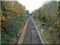
5
Wray Common Road railway bridge
Bridge carrying Wray Common Road over the Redhill - Reigate railway.
Image: © Ian Capper
Taken: 15 May 2020
0.04 miles
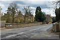
6
Redhill-Guildford railway
A view in the reverse direction to Image from the footbridge visible in that view, showing the road bridge that photograph was taken from.
Image: © Robin Webster
Taken: 17 Nov 2010
0.05 miles
7
37 Doods Park Road
Edwardian house in Doods Park Road. The 1963 1:1,250 map shows it with a name ratehr than a number: "Kemendene".
Image: © Ian Capper
Taken: 18 Jan 2021
0.05 miles
8
Wray Common Road railway bridge
Bridge carrying Wray Common Road over the Redhill - Reigate railway.
Image: © Ian Capper
Taken: 12 Apr 2021
0.05 miles
9
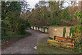
Dorchester Court
c.1960s block of flats in a former sand quarry off Wray Common Road. Because of its situation, the main access is towards the top of the building, although the driveway seen here leads to the floor of the quarry and the base of the building.
Image: © Ian Capper
Taken: 18 Jan 2021
0.05 miles
10
Garages, Dorchester Court
A row of garages serving Dorchester Court, a c.1960s block of flats in a former sand quarry off Wray Common Road. The garages are situated on the site of a former siding connecting the quarry to the Redhill - Reigate railway.
Image: © Ian Capper
Taken: 18 Jan 2021
0.06 miles