IMAGES TAKEN NEAR TO
Church Street, REIGATE, RH2 0AJ
Introduction
This page details the photographs taken nearby to Church Street, RH2 0AJ by members of the Geograph project.
The Geograph project started in 2005 with the aim of publishing, organising and preserving representative images for every square kilometre of Great Britain, Ireland and the Isle of Man.

There are currently over 7.5m images from over14,400 individuals and you can help contribute to the project by visiting https://www.geograph.org.uk
Image Map
Images are licensed for reuse under creativecommons.org/licenses/by-sa/2.0
Notes
- Clicking on the map will re-center to the selected point.
- The higher the marker number, the further away the image location is from the centre of the postcode.
Image Listing (796 Images Found)
Images are licensed for reuse under creativecommons.org/licenses/by-sa/2.0
Image
Details
Distance
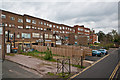
1
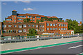
Rear of Church Street
The rear of buildings in Church Street, viewed from the top of the Bancroft Road car park. Beyond is The Observatory, headquarters of the insurers esure, completed in 2000.
Image: © Ian Capper
Taken: 12 Sep 2009
0.00 miles
2
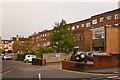
St Lawrences Way
Named after St Lawrence's Chapel, the remains of which are said to be incorporated in 15/15A Bell Street (see Image). The road acts as a service road to the back of shops and flats in Church Street.
Image: © Ian Capper
Taken: 13 May 2012
0.01 miles
3
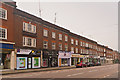
Church Street
Until the 1930s, much of the south side of Church Street consisted of gardens of the White Hart Hotel in Bell Street, demolished in 1935. Around that time these shops+flats, more typical of London outer suburbia high streets, were built.
Image: © Ian Capper
Taken: 13 May 2012
0.01 miles
4
Church Street
Until the 1930s, much of the south side of Church Street consisted of gardens of the White Hart Hotel in Bell Street, demolished in 1935. Around that time these shops+flats, more typical of London outer suburbia high streets, were built.
On the left is Bancroft Road.
Image: © Ian Capper
Taken: 13 May 2012
0.01 miles
5
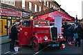
Reigate Christmas Fayre
A Dennis New World Light Four fire engine on display at Reigate Christmas Fayre. The Fayre, organised by Reigate Business Guild on 1 December 2012, included the closure of Church Street, as seen here, and culminated in the switching on of the town's Christmas lights.
The fire engine, built in 1939, was in service in East Sussex into the 1950s. It is now owned by the Horsham Veteran Fire Engine Preservation Group.
Image: © Ian Capper
Taken: 1 Dec 2012
0.01 miles
6
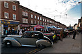
Reigate Christmas Fayre
Reigate Christmas Fayre was organised by Reigate Business Guild on 1 December 2012. It included the closure of Church Street, as seen here, and culminated in the switching on of the town's Christmas lights.
Image: © Ian Capper
Taken: 1 Dec 2012
0.01 miles
7
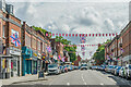
Church Street
Church Street adorned with flags in commemoration of Queen Elizabeth II's Platinum Jubilee.
Image: © Ian Capper
Taken: 31 May 2022
0.01 miles
8
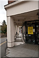
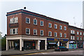
Bancroft Road
A colonnade at the end of the easternmost shopping parade in Church Street, at its corner with Bancroft Road (seen here). See Image for wider view.
Image: © Ian Capper
Taken: 8 Apr 2012
0.02 miles
9
St Lawrences Way
Rear of shops in Church Street, backing on to St Lawrences Way. St Lawrences Way was named after St Lawrence's Chapel, the remains of which are said to be incorporated in 15/15A Bell Street (see Image).
Image: © Ian Capper
Taken: 8 Apr 2012
0.02 miles
10
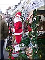
Reigate - Christmas Market
Father Christmas amongst the stalls on Church Street.
Image: © Colin Smith
Taken: 5 Dec 2015
0.02 miles