IMAGES TAKEN NEAR TO
Hawthorn Way, PULBOROUGH, RH20 4NL
Introduction
This page details the photographs taken nearby to Hawthorn Way, RH20 4NL by members of the Geograph project.
The Geograph project started in 2005 with the aim of publishing, organising and preserving representative images for every square kilometre of Great Britain, Ireland and the Isle of Man.

There are currently over 7.5m images from over14,400 individuals and you can help contribute to the project by visiting https://www.geograph.org.uk
Image Map
Images are licensed for reuse under creativecommons.org/licenses/by-sa/2.0
Notes
- Clicking on the map will re-center to the selected point.
- The higher the marker number, the further away the image location is from the centre of the postcode.
Image Listing (67 Images Found)
Images are licensed for reuse under creativecommons.org/licenses/by-sa/2.0
Image
Details
Distance
1
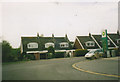
Houses on Old Mill Drive, Storrington
Image: © David Howard archives
Taken: Unknown
0.09 miles
3
Houses on Old Mill Drive, Storrington
Image: © David Howard archives
Taken: Unknown
0.11 miles
5
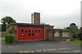
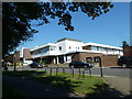
Storrington Fire Station
Storrington Fire Station, School Hill, Storrington, West Sussex
Image: © Kevin Hale
Taken: 7 May 2007
0.16 miles
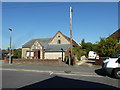
7
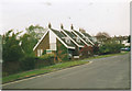
Storrington Chapel, North Street
Evangelical Free Church built in the 1930s.
Image: © Simon Carey
Taken: 11 Oct 2008
0.16 miles
8
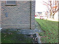
Ordnance Survey Bench mark
Cut mark "TEL EX SE SIDE SCHOOL HILL OPP NO45 NE FACE N ANG" 49.2700m 0.5 metres above ground.
Image: © The Saunterer
Taken: 14 Nov 2012
0.16 miles
9
Oops! I am home.
An unusual house name plate.
Image: © Peter Jeffery
Taken: Unknown
0.17 miles